You are here: Home > Network List > AV - Alaska Volcano Observatory Stations List
> Station SPCR Ckakachatna River, Mount Spurr, Alaska > Earthquake Result Viewer
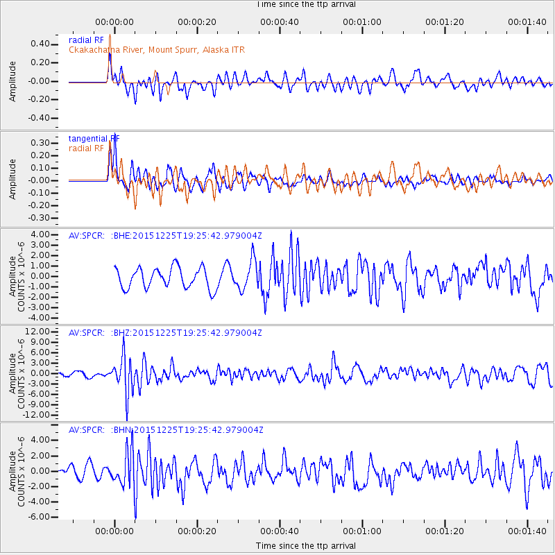
SPCR Ckakachatna River, Mount Spurr, Alaska - Earthquake Result Viewer
*The percent match for this event was below the threshold and hence no stack was calculated.
| Earthquake location: |
Afghanistan-Tajikistan Bord Reg. |
| Earthquake latitude/longitude: |
36.5/71.1 |
| Earthquake time(UTC): |
2015/12/25 (359) 19:14:48 GMT |
| Earthquake Depth: |
204 km |
| Earthquake Magnitude: |
6.2 MO |
| Earthquake Catalog/Contributor: |
NEIC PDE/NEIC ALERT |
|
| Network: |
AV Alaska Volcano Observatory |
| Station: |
SPCR Ckakachatna River, Mount Spurr, Alaska |
| Lat/Lon: |
61.20 N/152.21 W |
| Elevation: |
984 m |
|
| Distance: |
76.4 deg |
| Az: |
19.994 deg |
| Baz: |
325.331 deg |
| Ray Param: |
$rayparam |
*The percent match for this event was below the threshold and hence was not used in the summary stack. |
|
| Radial Match: |
57.44328 % |
| Radial Bump: |
400 |
| Transverse Match: |
53.73346 % |
| Transverse Bump: |
372 |
| SOD ConfigId: |
7422571 |
| Insert Time: |
2019-04-21 15:44:32.882 +0000 |
| GWidth: |
2.5 |
| Max Bumps: |
400 |
| Tol: |
0.001 |
|
Signal To Noise
| Channel | StoN | STA | LTA |
| AV:SPCR: :BHZ:20151225T19:25:42.979004Z | 8.629756 | 5.29613E-6 | 6.1370565E-7 |
| AV:SPCR: :BHN:20151225T19:25:42.979004Z | 2.7036524 | 2.2268498E-6 | 8.23645E-7 |
| AV:SPCR: :BHE:20151225T19:25:42.979004Z | 1.5485127 | 1.4847443E-6 | 9.588196E-7 |
| Arrivals |
| Ps | |
| PpPs | |
| PsPs/PpSs | |


