LSA Tibet, China - Earthquake Result Viewer
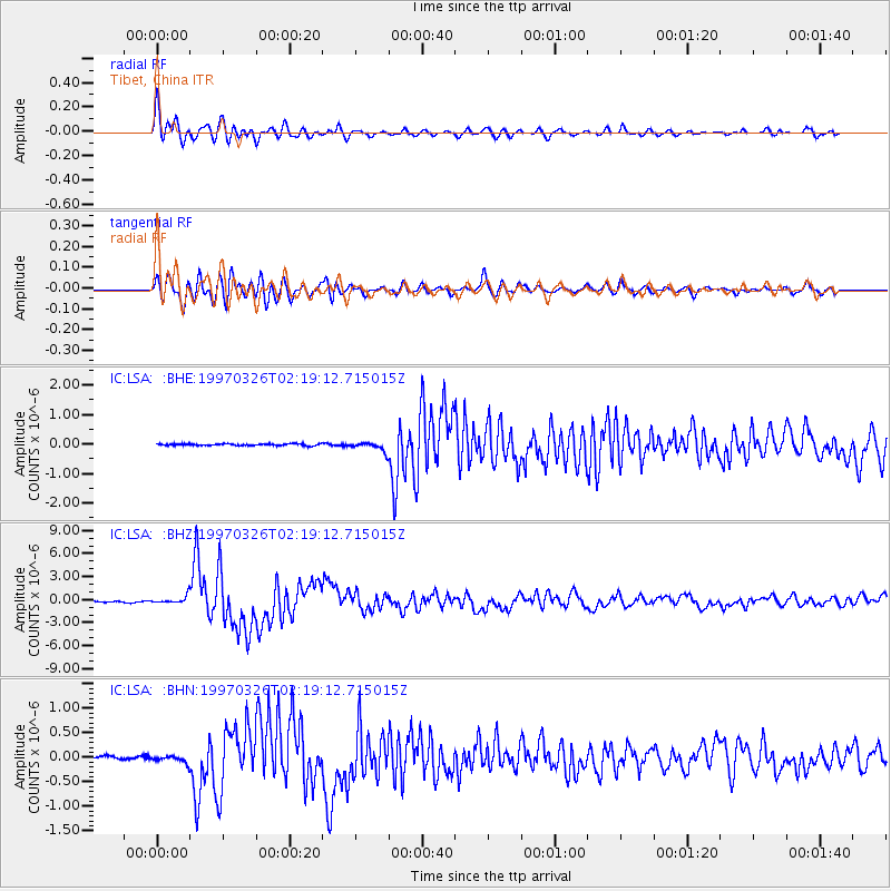
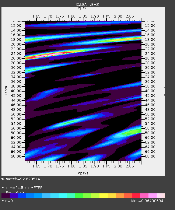
Earthquake location: Rat Islands, Aleutian Islands
Earthquake latitude/longitude: 51.3/179.5
Earthquake time(UTC): 1997/03/26 (085) 02:08:57 GMT
Earthquake Depth: 33 km
Earthquake Magnitude: 6.0 MB, 6.5 MS, 6.7 UNKNOWN, 6.3 ML
Earthquake Catalog/Contributor: WHDF/NEIC
Network: IC New China Digital Seismograph Network
Station: LSA Tibet, China
Lat/Lon: 29.70 N/91.15 E
Elevation: 3789 m
Distance: 66.5 deg
Az: 288.472 deg
Baz: 43.214 deg
Ray Param: 0.057533063
Estimated Moho Depth: 24.5 km
Estimated Crust Vp/Vs: 1.70
Assumed Crust Vp: 6.514 km/s
Estimated Crust Vs: 3.838 km/s
Estimated Crust Poisson's Ratio: 0.23
Radial Match: 92.620514 %
Radial Bump: 400
Transverse Match: 85.89606 %
Transverse Bump: 400
SOD ConfigId: 4480
Insert Time: 2010-03-04 22:54:13.130 +0000
GWidth: 2.5
Max Bumps: 400
Tol: 0.001

Signal To Noise

ChannelStoNSTALTA
IC:LSA: :BHZ:19970326T02:19:12.715015Z5.834234.9527625E-78.4891454E-8
IC:LSA: :BHN:19970326T02:19:12.715015Z1.9932857.369561E-83.697194E-8
IC:LSA: :BHE:19970326T02:19:12.715015Z4.7797721.3781236E-72.8832414E-8
Arrivals
Ps2.7 SECOND
PpPs9.7 SECOND
PsPs/PpSs12 SECOND