You are here: Home > Network List > IC - New China Digital Seismograph Network Stations List
> Station LSA Tibet, China > Earthquake Result Viewer
LSA Tibet, China - Earthquake Result Viewer
| Earthquake location: |
Mid-Indian Ridge |
| Earthquake latitude/longitude: |
-41.3/80.7 |
| Earthquake time(UTC): |
1996/06/06 (158) 17:35:38 GMT |
| Earthquake Depth: |
20 km |
| Earthquake Magnitude: |
5.5 MB, 5.9 MS, 6.3 UNKNOWN, 6.2 MW |
| Earthquake Catalog/Contributor: |
WHDF/NEIC |
|
| Network: |
IC New China Digital Seismograph Network |
| Station: |
LSA Tibet, China |
| Lat/Lon: |
29.70 N/91.15 E |
| Elevation: |
3789 m |
|
| Distance: |
71.3 deg |
| Az: |
9.62 deg |
| Baz: |
188.317 deg |
| Ray Param: |
0.054376572 |
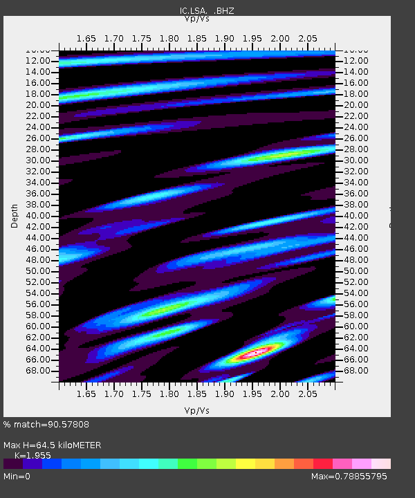
| Estimated Moho Depth: |
64.5 km |
| Estimated Crust Vp/Vs: |
1.96 |
| Assumed Crust Vp: |
6.514 km/s |
| Estimated Crust Vs: |
3.332 km/s |
| Estimated Crust Poisson's Ratio: |
0.32 |
|
| Radial Match: |
90.57808 % |
| Radial Bump: |
400 |
| Transverse Match: |
87.25808 % |
| Transverse Bump: |
400 |
| SOD ConfigId: |
4480 |
| Insert Time: |
2010-03-04 22:54:15.656 +0000 |
| GWidth: |
2.5 |
| Max Bumps: |
400 |
| Tol: |
0.001 |
|
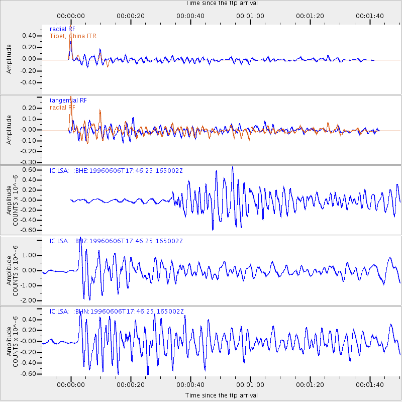
Signal To Noise
| Channel | StoN | STA | LTA |
| IC:LSA: :BHZ:19960606T17:46:25.165002Z | 18.262083 | 9.196589E-7 | 5.0358924E-8 |
| IC:LSA: :BHN:19960606T17:46:25.165002Z | 9.482414 | 2.2114904E-7 | 2.3322018E-8 |
| IC:LSA: :BHE:19960606T17:46:25.165002Z | 2.1597435 | 5.5018614E-8 | 2.5474604E-8 |
| Arrivals |
| Ps | 9.8 SECOND |
| PpPs | 28 SECOND |
| PsPs/PpSs | 38 SECOND |


