You are here: Home > Network List > IC - New China Digital Seismograph Network Stations List
> Station LSA Tibet, China > Earthquake Result Viewer
LSA Tibet, China - Earthquake Result Viewer
| Earthquake location: |
Mariana Islands |
| Earthquake latitude/longitude: |
17.4/145.5 |
| Earthquake time(UTC): |
1996/06/09 (161) 01:12:16 GMT |
| Earthquake Depth: |
149 km |
| Earthquake Magnitude: |
6.0 MB, 5.9 MS, 6.5 UNKNOWN, 6.5 MW |
| Earthquake Catalog/Contributor: |
WHDF/NEIC |
|
| Network: |
IC New China Digital Seismograph Network |
| Station: |
LSA Tibet, China |
| Lat/Lon: |
29.70 N/91.15 E |
| Elevation: |
3789 m |
|
| Distance: |
50.8 deg |
| Az: |
294.318 deg |
| Baz: |
91.131 deg |
| Ray Param: |
0.06728637 |
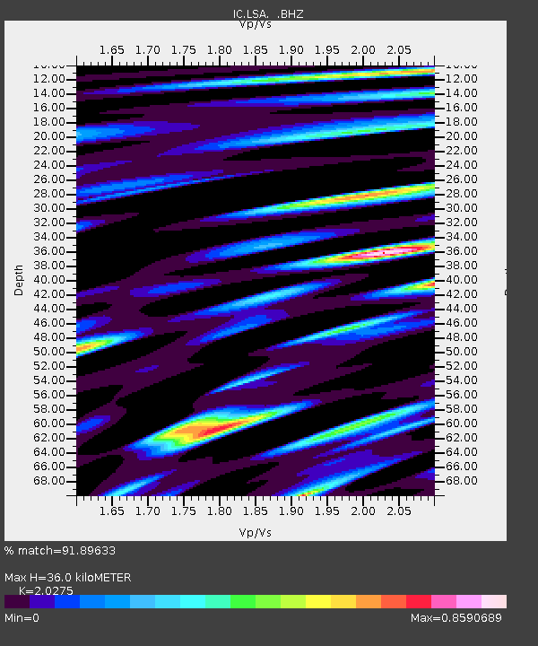
| Estimated Moho Depth: |
36.0 km |
| Estimated Crust Vp/Vs: |
2.03 |
| Assumed Crust Vp: |
6.514 km/s |
| Estimated Crust Vs: |
3.213 km/s |
| Estimated Crust Poisson's Ratio: |
0.34 |
|
| Radial Match: |
91.89633 % |
| Radial Bump: |
400 |
| Transverse Match: |
72.79118 % |
| Transverse Bump: |
400 |
| SOD ConfigId: |
4480 |
| Insert Time: |
2010-03-04 22:54:20.113 +0000 |
| GWidth: |
2.5 |
| Max Bumps: |
400 |
| Tol: |
0.001 |
|
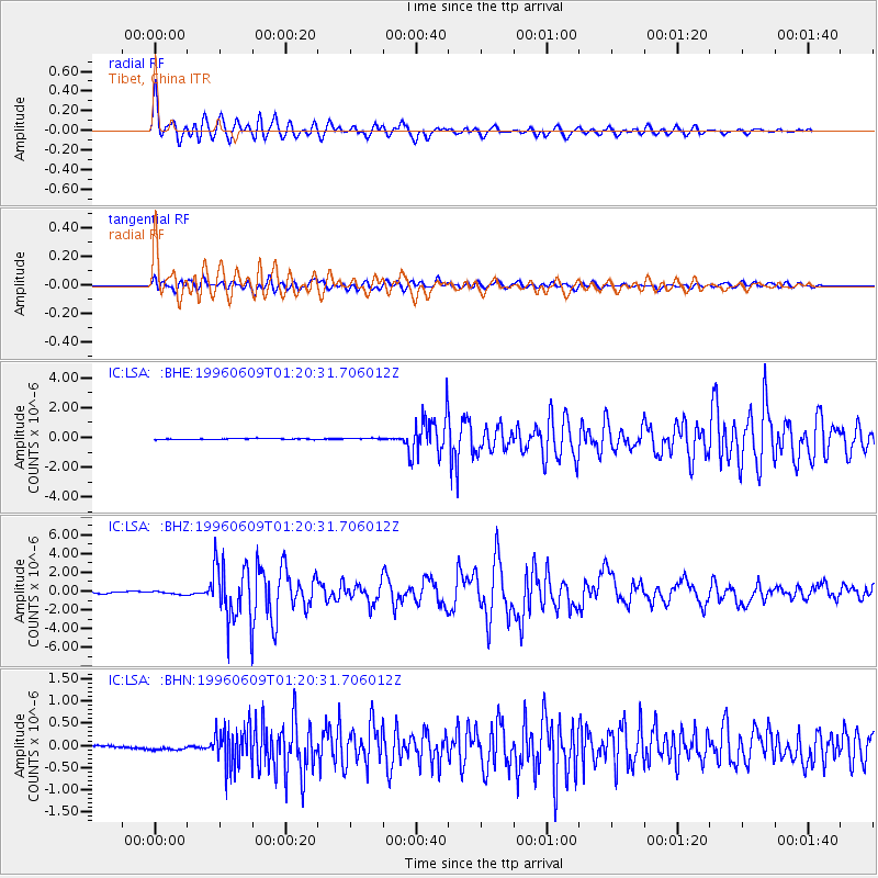
Signal To Noise
| Channel | StoN | STA | LTA |
| IC:LSA: :BHZ:19960609T01:20:31.706012Z | 1.4354583 | 1.5805169E-7 | 1.1010539E-7 |
| IC:LSA: :BHN:19960609T01:20:31.706012Z | 0.5308246 | 4.0152493E-8 | 7.5641736E-8 |
| IC:LSA: :BHE:19960609T01:20:31.706012Z | 1.5043509 | 5.1096507E-8 | 3.3965815E-8 |
| Arrivals |
| Ps | 6.0 SECOND |
| PpPs | 16 SECOND |
| PsPs/PpSs | 22 SECOND |


