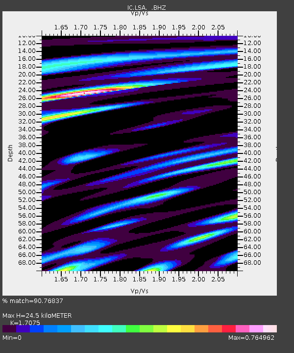
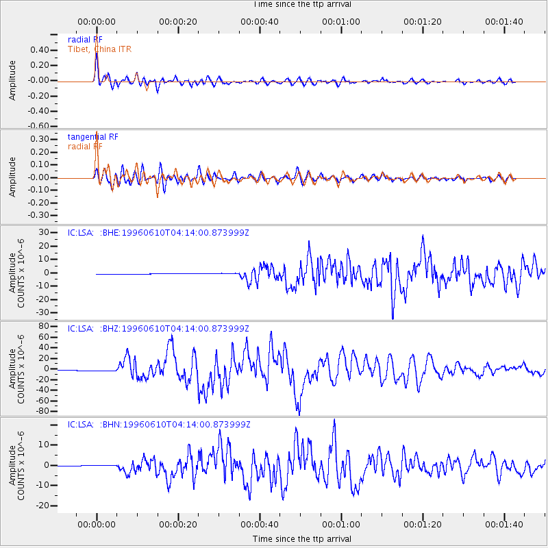
LSA Tibet, China - Earthquake Result Viewer

Earthquake location: Andreanof Islands, Aleutian Is.
Earthquake latitude/longitude: 51.6/-177.6
Earthquake time(UTC): 1996/06/10 (162) 04:03:35 GMT
Earthquake Depth: 33 km
Earthquake Magnitude: 6.6 MB, 7.6 MS, 7.9 UNKNOWN, 7.4 MS
Earthquake Catalog/Contributor: WHDF/NEIC
Network: IC New China Digital Seismograph Network
Station: LSA Tibet, China
Lat/Lon: 29.70 N/91.15 E
Elevation: 3789 m
Distance: 68.1 deg
Az: 290.322 deg
Baz: 42.281 deg
Ray Param: 0.056497913
Estimated Moho Depth: 24.5 km
Estimated Crust Vp/Vs: 1.71
Assumed Crust Vp: 6.514 km/s
Estimated Crust Vs: 3.815 km/s
Estimated Crust Poisson's Ratio: 0.24
Radial Match: 90.76837 %
Radial Bump: 400
Transverse Match: 85.21122 %
Transverse Bump: 400
SOD ConfigId: 4480
Insert Time: 2010-03-04 22:54:23.435 +0000
GWidth: 2.5
Max Bumps: 400
Tol: 0.001

Signal To Noise

ChannelStoNSTALTA
IC:LSA: :BHZ:19960610T04:14:00.873999Z2.95645361.4449826E-64.8875535E-7
IC:LSA: :BHN:19960610T04:14:00.873999Z4.0939723.4167178E-78.345727E-8
IC:LSA: :BHE:19960610T04:14:00.873999Z4.1130944.2696888E-71.03807224E-7
Arrivals
Ps2.8 SECOND
PpPs9.8 SECOND
PsPs/PpSs13 SECOND