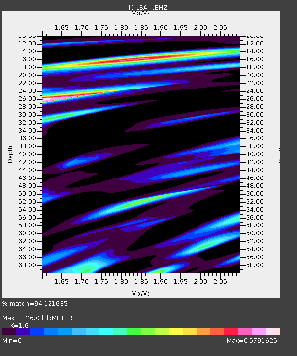
LSA Tibet, China - Earthquake Result Viewer
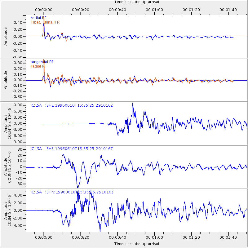
Earthquake location: Andreanof Islands, Aleutian Is.
Earthquake latitude/longitude: 51.5/-176.8
Earthquake time(UTC): 1996/06/10 (162) 15:24:56 GMT
Earthquake Depth: 26 km
Earthquake Magnitude: 5.9 MB, 7.1 MS, 7.2 UNKNOWN, 6.9 MS
Earthquake Catalog/Contributor: WHDF/NEIC
Network: IC New China Digital Seismograph Network
Station: LSA Tibet, China
Lat/Lon: 29.70 N/91.15 E
Elevation: 3789 m
Distance: 68.6 deg
Az: 290.898 deg
Baz: 42.182 deg
Ray Param: 0.056194372
Estimated Moho Depth: 26.0 km
Estimated Crust Vp/Vs: 1.60
Assumed Crust Vp: 6.514 km/s
Estimated Crust Vs: 4.071 km/s
Estimated Crust Poisson's Ratio: 0.18
Radial Match: 94.121635 %
Radial Bump: 400
Transverse Match: 89.46942 %
Transverse Bump: 400
SOD ConfigId: 4480
Insert Time: 2010-03-04 22:54:26.301 +0000
GWidth: 2.5
Max Bumps: 400
Tol: 0.001

Signal To Noise

ChannelStoNSTALTA
IC:LSA: :BHZ:19960610T15:35:25.291016Z1.77589813.2988268E-71.8575541E-7
IC:LSA: :BHN:19960610T15:35:25.291016Z2.15348431.3999828E-76.501012E-8
IC:LSA: :BHE:19960610T15:35:25.291016Z1.62334281.2785257E-77.875883E-8
Arrivals
Ps2.5 SECOND
PpPs9.9 SECOND
PsPs/PpSs12 SECOND