You are here: Home > Network List > IC - New China Digital Seismograph Network Stations List
> Station LSA Tibet, China > Earthquake Result Viewer
LSA Tibet, China - Earthquake Result Viewer
| Earthquake location: |
Mid-Indian Ridge |
| Earthquake latitude/longitude: |
-26.5/74.5 |
| Earthquake time(UTC): |
1999/01/24 (024) 08:00:08 GMT |
| Earthquake Depth: |
10 km |
| Earthquake Magnitude: |
6.0 MB, 6.3 MS, 6.3 MW, 6.3 ME |
| Earthquake Catalog/Contributor: |
WHDF/NEIC |
|
| Network: |
IC New China Digital Seismograph Network |
| Station: |
LSA Tibet, China |
| Lat/Lon: |
29.70 N/91.15 E |
| Elevation: |
3789 m |
|
| Distance: |
58.1 deg |
| Az: |
17.103 deg |
| Baz: |
197.638 deg |
| Ray Param: |
0.06307401 |
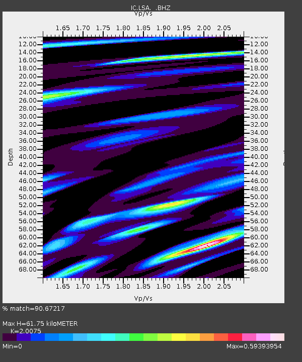
| Estimated Moho Depth: |
61.75 km |
| Estimated Crust Vp/Vs: |
2.01 |
| Assumed Crust Vp: |
6.514 km/s |
| Estimated Crust Vs: |
3.245 km/s |
| Estimated Crust Poisson's Ratio: |
0.33 |
|
| Radial Match: |
90.67217 % |
| Radial Bump: |
400 |
| Transverse Match: |
84.9896 % |
| Transverse Bump: |
400 |
| SOD ConfigId: |
4480 |
| Insert Time: |
2010-03-04 22:54:34.675 +0000 |
| GWidth: |
2.5 |
| Max Bumps: |
400 |
| Tol: |
0.001 |
|
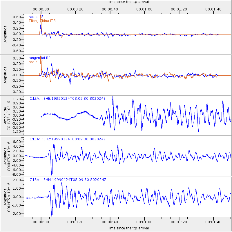
Signal To Noise
| Channel | StoN | STA | LTA |
| IC:LSA: :BHZ:19990124T08:09:30.802024Z | 2.932778 | 6.62173E-7 | 2.2578355E-7 |
| IC:LSA: :BHN:19990124T08:09:30.802024Z | 2.4798152 | 1.5609179E-7 | 6.294492E-8 |
| IC:LSA: :BHE:19990124T08:09:30.802024Z | 0.9751788 | 1.6017812E-7 | 1.6425513E-7 |
| Arrivals |
| Ps | 10.0 SECOND |
| PpPs | 27 SECOND |
| PsPs/PpSs | 37 SECOND |


