You are here: Home > Network List > LX - University of LISbon SEISmic Network Stations List
> Station MORF Marmelete, Algarve, Portugal > Earthquake Result Viewer
MORF Marmelete, Algarve, Portugal - Earthquake Result Viewer
| Earthquake location: |
Afghanistan-Tajikistan Bord Reg. |
| Earthquake latitude/longitude: |
36.5/71.1 |
| Earthquake time(UTC): |
2015/12/25 (359) 19:14:48 GMT |
| Earthquake Depth: |
204 km |
| Earthquake Magnitude: |
6.2 MO |
| Earthquake Catalog/Contributor: |
NEIC PDE/NEIC ALERT |
|
| Network: |
LX University of LISbon SEISmic Network |
| Station: |
MORF Marmelete, Algarve, Portugal |
| Lat/Lon: |
37.30 N/8.65 W |
| Elevation: |
560 m |
|
| Distance: |
61.9 deg |
| Az: |
297.148 deg |
| Baz: |
64.028 deg |
| Ray Param: |
0.05996037 |
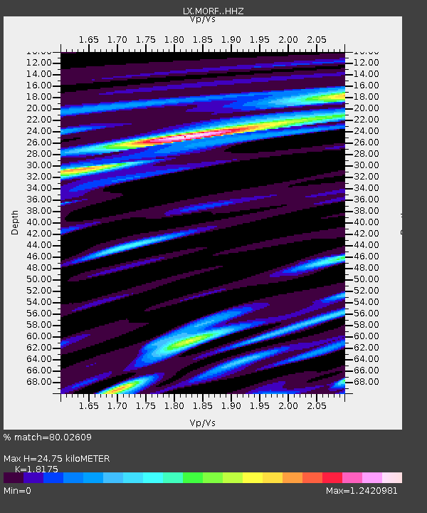
| Estimated Moho Depth: |
24.75 km |
| Estimated Crust Vp/Vs: |
1.82 |
| Assumed Crust Vp: |
6.048 km/s |
| Estimated Crust Vs: |
3.328 km/s |
| Estimated Crust Poisson's Ratio: |
0.28 |
|
| Radial Match: |
80.02609 % |
| Radial Bump: |
400 |
| Transverse Match: |
66.88205 % |
| Transverse Bump: |
400 |
| SOD ConfigId: |
7422571 |
| Insert Time: |
2019-04-21 15:47:19.711 +0000 |
| GWidth: |
2.5 |
| Max Bumps: |
400 |
| Tol: |
0.001 |
|

Signal To Noise
| Channel | StoN | STA | LTA |
| LX:MORF: :HHZ:20151225T19:24:13.784973Z | 5.1255093 | 2.6019036E-6 | 5.0763805E-7 |
| LX:MORF: :HHN:20151225T19:24:13.784973Z | 1.4045522 | 6.253673E-7 | 4.4524316E-7 |
| LX:MORF: :HHE:20151225T19:24:13.784973Z | 4.1105123 | 1.2355338E-6 | 3.0057905E-7 |
| Arrivals |
| Ps | 3.5 SECOND |
| PpPs | 11 SECOND |
| PsPs/PpSs | 15 SECOND |


