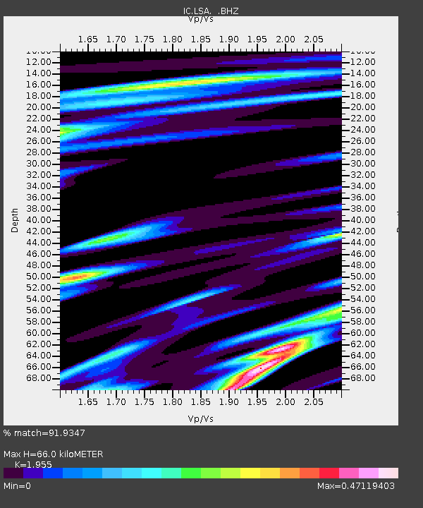
LSA Tibet, China - Earthquake Result Viewer
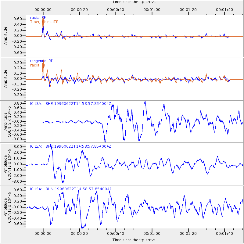
Earthquake location: Off East Coast Of Kamchatka
Earthquake latitude/longitude: 51.4/159.2
Earthquake time(UTC): 1996/06/22 (174) 14:50:07 GMT
Earthquake Depth: 33 km
Earthquake Magnitude: 5.6 MB, 6.0 MS, 6.2 UNKNOWN, 6.2 MW
Earthquake Catalog/Contributor: WHDF/NEIC
Network: IC New China Digital Seismograph Network
Station: LSA Tibet, China
Lat/Lon: 29.70 N/91.15 E
Elevation: 3789 m
Distance: 54.0 deg
Az: 273.951 deg
Baz: 45.916 deg
Ray Param: 0.06565642
Estimated Moho Depth: 66.0 km
Estimated Crust Vp/Vs: 1.96
Assumed Crust Vp: 6.514 km/s
Estimated Crust Vs: 3.332 km/s
Estimated Crust Poisson's Ratio: 0.32
Radial Match: 91.9347 %
Radial Bump: 320
Transverse Match: 83.24119 %
Transverse Bump: 400
SOD ConfigId: 4480
Insert Time: 2010-03-04 22:54:54.597 +0000
GWidth: 2.5
Max Bumps: 400
Tol: 0.001

Signal To Noise

ChannelStoNSTALTA
IC:LSA: :BHZ:19960622T14:58:57.854004Z21.7519721.404439E-66.456605E-8
IC:LSA: :BHN:19960622T14:58:57.854004Z10.8849212.524137E-72.3189303E-8
IC:LSA: :BHE:19960622T14:58:57.854004Z12.6063653.833566E-73.0409765E-8
Arrivals
Ps10 SECOND
PpPs28 SECOND
PsPs/PpSs39 SECOND