You are here: Home > Network List > IC - New China Digital Seismograph Network Stations List
> Station LSA Tibet, China > Earthquake Result Viewer
LSA Tibet, China - Earthquake Result Viewer
| Earthquake location: |
East Of Kuril Islands |
| Earthquake latitude/longitude: |
46.2/154.4 |
| Earthquake time(UTC): |
2006/12/07 (341) 19:10:21 GMT |
| Earthquake Depth: |
16 km |
| Earthquake Magnitude: |
6.3 MB, 6.1 MS, 6.3 MW, 6.3 MW |
| Earthquake Catalog/Contributor: |
WHDF/NEIC |
|
| Network: |
IC New China Digital Seismograph Network |
| Station: |
LSA Tibet, China |
| Lat/Lon: |
29.70 N/91.15 E |
| Elevation: |
3789 m |
|
| Distance: |
51.2 deg |
| Az: |
274.491 deg |
| Baz: |
52.799 deg |
| Ray Param: |
0.06755422 |
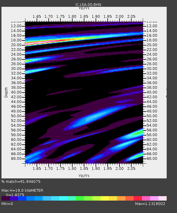
| Estimated Moho Depth: |
19.0 km |
| Estimated Crust Vp/Vs: |
1.64 |
| Assumed Crust Vp: |
6.514 km/s |
| Estimated Crust Vs: |
3.978 km/s |
| Estimated Crust Poisson's Ratio: |
0.20 |
|
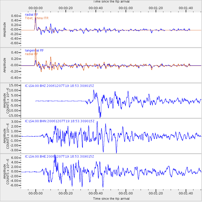
| Radial Match: |
91.946075 % |
| Radial Bump: |
400 |
| Transverse Match: |
87.75968 % |
| Transverse Bump: |
400 |
| SOD ConfigId: |
2564 |
| Insert Time: |
2010-03-04 22:55:07.773 +0000 |
| GWidth: |
2.5 |
| Max Bumps: |
400 |
| Tol: |
0.001 |
|
Signal To Noise
| Channel | StoN | STA | LTA |
| IC:LSA:00:BHN:20061207T19:18:53.309015Z | 4.4211483 | 1.1725489E-7 | 2.6521366E-8 |
| IC:LSA:00:BHE:20061207T19:18:53.309015Z | 7.90386 | 3.8840798E-7 | 4.914156E-8 |
| IC:LSA:00:BHZ:20061207T19:18:53.309015Z | 16.29414 | 8.420958E-7 | 5.16809E-8 |
| Arrivals |
| Ps | 2.0 SECOND |
| PpPs | 7.2 SECOND |
| PsPs/PpSs | 9.2 SECOND |


