You are here: Home > Network List > RV - Regional Alberta Seismic Observatory for Earthquake Studies Network Stations List
> Station WAPA Wapiti River, AB > Earthquake Result Viewer
WAPA Wapiti River, AB - Earthquake Result Viewer
| Earthquake location: |
Afghanistan-Tajikistan Bord Reg. |
| Earthquake latitude/longitude: |
36.5/71.1 |
| Earthquake time(UTC): |
2015/12/25 (359) 19:14:48 GMT |
| Earthquake Depth: |
204 km |
| Earthquake Magnitude: |
6.2 MO |
| Earthquake Catalog/Contributor: |
NEIC PDE/NEIC ALERT |
|
| Network: |
RV Regional Alberta Seismic Observatory for Earthquake Studies Network |
| Station: |
WAPA Wapiti River, AB |
| Lat/Lon: |
55.18 N/119.25 W |
| Elevation: |
784 m |
|
| Distance: |
88.2 deg |
| Az: |
5.939 deg |
| Baz: |
351.643 deg |
| Ray Param: |
0.042264577 |
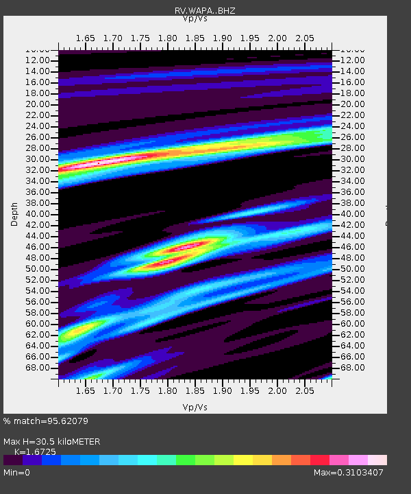
| Estimated Moho Depth: |
30.5 km |
| Estimated Crust Vp/Vs: |
1.67 |
| Assumed Crust Vp: |
6.161 km/s |
| Estimated Crust Vs: |
3.684 km/s |
| Estimated Crust Poisson's Ratio: |
0.22 |
|
| Radial Match: |
95.62079 % |
| Radial Bump: |
219 |
| Transverse Match: |
76.03677 % |
| Transverse Bump: |
386 |
| SOD ConfigId: |
7422571 |
| Insert Time: |
2019-04-21 15:48:59.565 +0000 |
| GWidth: |
2.5 |
| Max Bumps: |
400 |
| Tol: |
0.001 |
|

Signal To Noise
| Channel | StoN | STA | LTA |
| RV:WAPA: :BHZ:20151225T19:26:43.750Z | 10.996036 | 5.704506E-6 | 5.1877845E-7 |
| RV:WAPA: :BHN:20151225T19:26:43.750Z | 8.825155 | 2.4182034E-6 | 2.7401256E-7 |
| RV:WAPA: :BHE:20151225T19:26:43.750Z | 6.319728 | 1.923348E-6 | 3.0434032E-7 |
| Arrivals |
| Ps | 3.4 SECOND |
| PpPs | 13 SECOND |
| PsPs/PpSs | 16 SECOND |


