You are here: Home > Network List > TA - USArray Transportable Network (new EarthScope stations) Stations List
> Station A04D Lummi Island, WA, USA > Earthquake Result Viewer
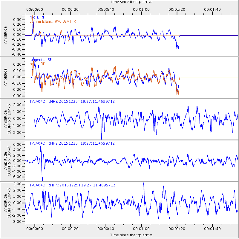
A04D Lummi Island, WA, USA - Earthquake Result Viewer
*The percent match for this event was below the threshold and hence no stack was calculated.
| Earthquake location: |
Afghanistan-Tajikistan Bord Reg. |
| Earthquake latitude/longitude: |
36.5/71.1 |
| Earthquake time(UTC): |
2015/12/25 (359) 19:14:48 GMT |
| Earthquake Depth: |
204 km |
| Earthquake Magnitude: |
6.2 MO |
| Earthquake Catalog/Contributor: |
NEIC PDE/NEIC ALERT |
|
| Network: |
TA USArray Transportable Network (new EarthScope stations) |
| Station: |
A04D Lummi Island, WA, USA |
| Lat/Lon: |
48.72 N/122.71 W |
| Elevation: |
13 m |
|
| Distance: |
94.2 deg |
| Az: |
9.141 deg |
| Baz: |
348.857 deg |
| Ray Param: |
$rayparam |
*The percent match for this event was below the threshold and hence was not used in the summary stack. |
|
| Radial Match: |
47.124153 % |
| Radial Bump: |
380 |
| Transverse Match: |
52.512527 % |
| Transverse Bump: |
400 |
| SOD ConfigId: |
7422571 |
| Insert Time: |
2019-04-21 15:49:18.897 +0000 |
| GWidth: |
2.5 |
| Max Bumps: |
400 |
| Tol: |
0.001 |
|
Signal To Noise
| Channel | StoN | STA | LTA |
| TA:A04D: :HHZ:20151225T19:27:11.469971Z | 4.3434687 | 2.7426006E-6 | 6.3143096E-7 |
| TA:A04D: :HHN:20151225T19:27:11.469971Z | 1.3163029 | 9.779517E-7 | 7.4295343E-7 |
| TA:A04D: :HHE:20151225T19:27:11.469971Z | 1.4997674 | 6.582938E-7 | 4.389306E-7 |
| Arrivals |
| Ps | |
| PpPs | |
| PsPs/PpSs | |


