You are here: Home > Network List > TA - USArray Transportable Network (new EarthScope stations) Stations List
> Station A21K Barrow, AK, USA > Earthquake Result Viewer
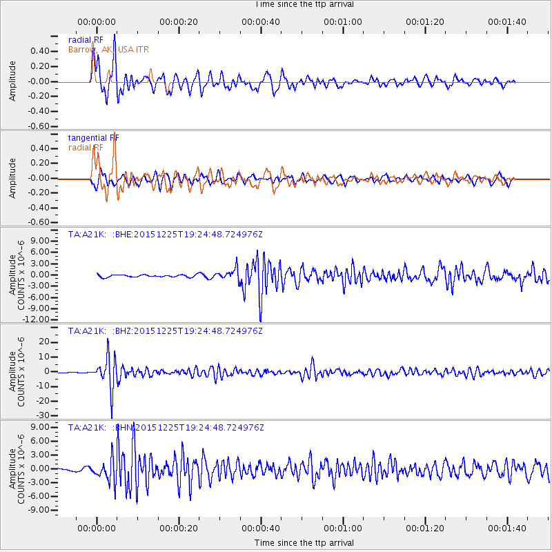
A21K Barrow, AK, USA - Earthquake Result Viewer
*The percent match for this event was below the threshold and hence no stack was calculated.
| Earthquake location: |
Afghanistan-Tajikistan Bord Reg. |
| Earthquake latitude/longitude: |
36.5/71.1 |
| Earthquake time(UTC): |
2015/12/25 (359) 19:14:48 GMT |
| Earthquake Depth: |
204 km |
| Earthquake Magnitude: |
6.2 MO |
| Earthquake Catalog/Contributor: |
NEIC PDE/NEIC ALERT |
|
| Network: |
TA USArray Transportable Network (new EarthScope stations) |
| Station: |
A21K Barrow, AK, USA |
| Lat/Lon: |
71.32 N/156.62 W |
| Elevation: |
577 m |
|
| Distance: |
67.3 deg |
| Az: |
14.985 deg |
| Baz: |
319.717 deg |
| Ray Param: |
$rayparam |
*The percent match for this event was below the threshold and hence was not used in the summary stack. |
|
| Radial Match: |
85.79375 % |
| Radial Bump: |
400 |
| Transverse Match: |
75.474075 % |
| Transverse Bump: |
400 |
| SOD ConfigId: |
7422571 |
| Insert Time: |
2019-04-21 15:49:19.095 +0000 |
| GWidth: |
2.5 |
| Max Bumps: |
400 |
| Tol: |
0.001 |
|
Signal To Noise
| Channel | StoN | STA | LTA |
| TA:A21K: :BHZ:20151225T19:24:48.724976Z | 33.948917 | 1.0785731E-5 | 3.1770472E-7 |
| TA:A21K: :BHN:20151225T19:24:48.724976Z | 4.2229204 | 2.416034E-6 | 5.7212395E-7 |
| TA:A21K: :BHE:20151225T19:24:48.724976Z | 5.6152835 | 1.9580036E-6 | 3.4869186E-7 |
| Arrivals |
| Ps | |
| PpPs | |
| PsPs/PpSs | |


