You are here: Home > Network List > IC - New China Digital Seismograph Network Stations List
> Station LSA Tibet, China > Earthquake Result Viewer
LSA Tibet, China - Earthquake Result Viewer

| Earthquake location: |
East Of Kuril Islands |
| Earthquake latitude/longitude: |
46.4/154.5 |
| Earthquake time(UTC): |
2006/11/16 (320) 06:20:20 GMT |
| Earthquake Depth: |
9.0 km |
| Earthquake Magnitude: |
6.0 MB, 5.4 MS, 5.9 MW, 5.9 MW |
| Earthquake Catalog/Contributor: |
WHDF/NEIC |
|
| Network: |
IC New China Digital Seismograph Network |
| Station: |
LSA Tibet, China |
| Lat/Lon: |
29.70 N/91.15 E |
| Elevation: |
3789 m |
|
| Distance: |
51.2 deg |
| Az: |
274.383 deg |
| Baz: |
52.531 deg |
| Ray Param: |
0.06754553 |
| Estimated Moho Depth: |
19.0 km |
| Estimated Crust Vp/Vs: |
1.60 |
| Assumed Crust Vp: |
6.514 km/s |
| Estimated Crust Vs: |
4.071 km/s |
| Estimated Crust Poisson's Ratio: |
0.18 |
|
| Radial Match: |
93.74322 % |
| Radial Bump: |
400 |
| Transverse Match: |
89.94052 % |
| Transverse Bump: |
400 |
| SOD ConfigId: |
2564 |
| Insert Time: |
2010-03-04 22:55:19.007 +0000 |
| GWidth: |
2.5 |
| Max Bumps: |
400 |
| Tol: |
0.001 |
|
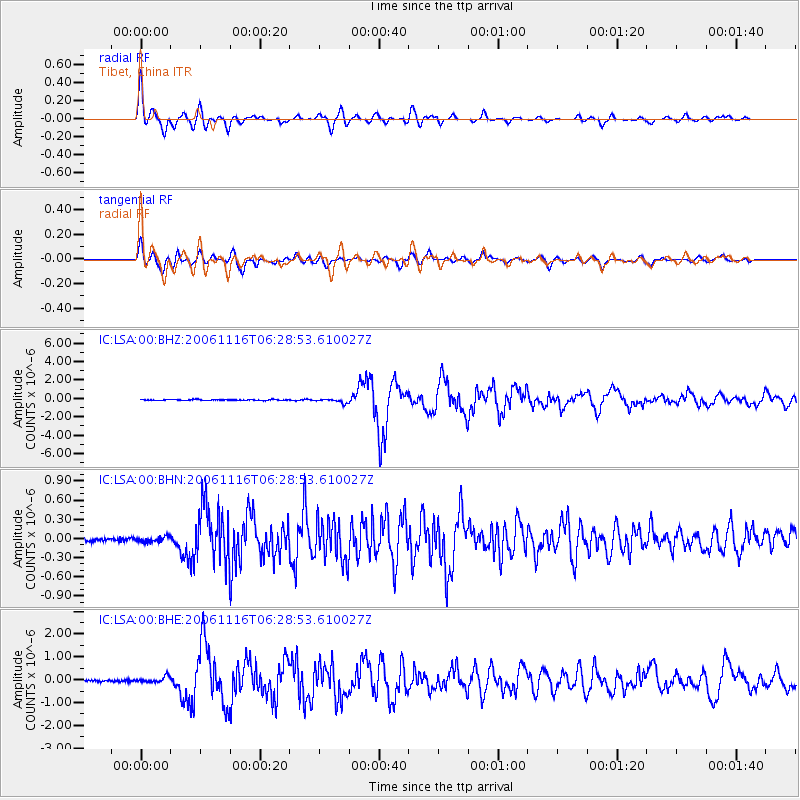
Signal To Noise
| Channel | StoN | STA | LTA |
| IC:LSA:00:BHN:20061116T06:28:53.610027Z | 1.3263464 | 3.979594E-8 | 3.000418E-8 |
| IC:LSA:00:BHE:20061116T06:28:53.610027Z | 2.4239967 | 1.2451403E-7 | 5.1367245E-8 |
| IC:LSA:00:BHZ:20061116T06:28:53.610027Z | 4.712306 | 2.1947571E-7 | 4.6575014E-8 |
| Arrivals |
| Ps | 1.9 SECOND |
| PpPs | 7.1 SECOND |
| PsPs/PpSs | 9.0 SECOND |


