You are here: Home > Network List > TA - USArray Transportable Network (new EarthScope stations) Stations List
> Station MDND Maddock, ND, USA > Earthquake Result Viewer
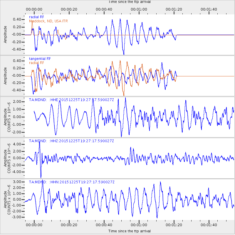
MDND Maddock, ND, USA - Earthquake Result Viewer
*The percent match for this event was below the threshold and hence no stack was calculated.
| Earthquake location: |
Afghanistan-Tajikistan Bord Reg. |
| Earthquake latitude/longitude: |
36.5/71.1 |
| Earthquake time(UTC): |
2015/12/25 (359) 19:14:48 GMT |
| Earthquake Depth: |
204 km |
| Earthquake Magnitude: |
6.2 MO |
| Earthquake Catalog/Contributor: |
NEIC PDE/NEIC ALERT |
|
| Network: |
TA USArray Transportable Network (new EarthScope stations) |
| Station: |
MDND Maddock, ND, USA |
| Lat/Lon: |
47.85 N/99.60 W |
| Elevation: |
479 m |
|
| Distance: |
95.6 deg |
| Az: |
353.746 deg |
| Baz: |
7.486 deg |
| Ray Param: |
$rayparam |
*The percent match for this event was below the threshold and hence was not used in the summary stack. |
|
| Radial Match: |
72.54448 % |
| Radial Bump: |
390 |
| Transverse Match: |
67.250496 % |
| Transverse Bump: |
340 |
| SOD ConfigId: |
7422571 |
| Insert Time: |
2019-04-21 15:49:38.442 +0000 |
| GWidth: |
2.5 |
| Max Bumps: |
400 |
| Tol: |
0.001 |
|
Signal To Noise
| Channel | StoN | STA | LTA |
| TA:MDND: :HHZ:20151225T19:27:17.590027Z | 4.6681404 | 2.2364168E-6 | 4.790809E-7 |
| TA:MDND: :HHN:20151225T19:27:17.590027Z | 3.225047 | 1.5194134E-6 | 4.7112906E-7 |
| TA:MDND: :HHE:20151225T19:27:17.590027Z | 1.2811881 | 1.2668429E-6 | 9.888032E-7 |
| Arrivals |
| Ps | |
| PpPs | |
| PsPs/PpSs | |


