You are here: Home > Network List > UW - Pacific Northwest Regional Seismic Network Stations List
> Station MRBL Marblemount, WA, USA > Earthquake Result Viewer
MRBL Marblemount, WA, USA - Earthquake Result Viewer
*The percent match for this event was below the threshold and hence no stack was calculated.
| Earthquake location: |
Afghanistan-Tajikistan Bord Reg. |
| Earthquake latitude/longitude: |
36.5/71.1 |
| Earthquake time(UTC): |
2015/12/25 (359) 19:14:48 GMT |
| Earthquake Depth: |
204 km |
| Earthquake Magnitude: |
6.2 MO |
| Earthquake Catalog/Contributor: |
NEIC PDE/NEIC ALERT |
|
| Network: |
UW Pacific Northwest Regional Seismic Network |
| Station: |
MRBL Marblemount, WA, USA |
| Lat/Lon: |
48.52 N/121.48 W |
| Elevation: |
75 m |
|
| Distance: |
94.6 deg |
| Az: |
8.38 deg |
| Baz: |
349.829 deg |
| Ray Param: |
$rayparam |
*The percent match for this event was below the threshold and hence was not used in the summary stack. |
|
| Radial Match: |
49.463966 % |
| Radial Bump: |
400 |
| Transverse Match: |
61.80461 % |
| Transverse Bump: |
400 |
| SOD ConfigId: |
7422571 |
| Insert Time: |
2019-04-21 15:50:17.239 +0000 |
| GWidth: |
2.5 |
| Max Bumps: |
400 |
| Tol: |
0.001 |
|
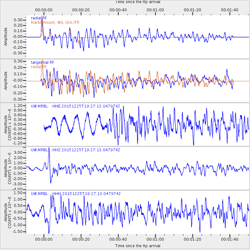
Signal To Noise
| Channel | StoN | STA | LTA |
| UW:MRBL: :HHZ:20151225T19:27:13.047974Z | 7.2260785 | 1.5689185E-6 | 2.1711894E-7 |
| UW:MRBL: :HHN:20151225T19:27:13.047974Z | 2.5226436 | 8.05559E-7 | 3.193313E-7 |
| UW:MRBL: :HHE:20151225T19:27:13.047974Z | 0.6371257 | 2.5623788E-7 | 4.0217793E-7 |
| Arrivals |
| Ps | |
| PpPs | |
| PsPs/PpSs | |


