You are here: Home > Network List > UW - Pacific Northwest Regional Seismic Network Stations List
> Station PASS Maple Falls, WA, USA > Earthquake Result Viewer
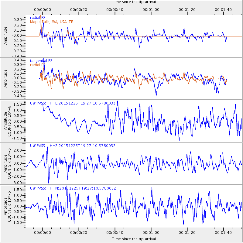
PASS Maple Falls, WA, USA - Earthquake Result Viewer
*The percent match for this event was below the threshold and hence no stack was calculated.
| Earthquake location: |
Afghanistan-Tajikistan Bord Reg. |
| Earthquake latitude/longitude: |
36.5/71.1 |
| Earthquake time(UTC): |
2015/12/25 (359) 19:14:48 GMT |
| Earthquake Depth: |
204 km |
| Earthquake Magnitude: |
6.2 MO |
| Earthquake Catalog/Contributor: |
NEIC PDE/NEIC ALERT |
|
| Network: |
UW Pacific Northwest Regional Seismic Network |
| Station: |
PASS Maple Falls, WA, USA |
| Lat/Lon: |
49.00 N/122.09 W |
| Elevation: |
174 m |
|
| Distance: |
94.1 deg |
| Az: |
8.685 deg |
| Baz: |
349.356 deg |
| Ray Param: |
$rayparam |
*The percent match for this event was below the threshold and hence was not used in the summary stack. |
|
| Radial Match: |
55.06065 % |
| Radial Bump: |
400 |
| Transverse Match: |
46.794754 % |
| Transverse Bump: |
400 |
| SOD ConfigId: |
7422571 |
| Insert Time: |
2019-04-21 15:50:17.310 +0000 |
| GWidth: |
2.5 |
| Max Bumps: |
400 |
| Tol: |
0.001 |
|
Signal To Noise
| Channel | StoN | STA | LTA |
| UW:PASS: :HHZ:20151225T19:27:10.578003Z | 2.3741674 | 1.3316055E-6 | 5.6087265E-7 |
| UW:PASS: :HHN:20151225T19:27:10.578003Z | 2.4932635 | 4.855383E-7 | 1.9474007E-7 |
| UW:PASS: :HHE:20151225T19:27:10.578003Z | 0.65392643 | 3.9850678E-7 | 6.0940613E-7 |
| Arrivals |
| Ps | |
| PpPs | |
| PsPs/PpSs | |


