You are here: Home > Network List > IC - New China Digital Seismograph Network Stations List
> Station LSA Tibet, China > Earthquake Result Viewer
LSA Tibet, China - Earthquake Result Viewer
| Earthquake location: |
Kuril Islands |
| Earthquake latitude/longitude: |
46.3/153.3 |
| Earthquake time(UTC): |
2006/10/13 (286) 13:47:39 GMT |
| Earthquake Depth: |
8.0 km |
| Earthquake Magnitude: |
5.5 MB, 5.8 MS, 6.3 MW, 5.8 MW |
| Earthquake Catalog/Contributor: |
WHDF/NEIC |
|
| Network: |
IC New China Digital Seismograph Network |
| Station: |
LSA Tibet, China |
| Lat/Lon: |
29.70 N/91.15 E |
| Elevation: |
3789 m |
|
| Distance: |
50.4 deg |
| Az: |
273.659 deg |
| Baz: |
52.742 deg |
| Ray Param: |
0.06807677 |
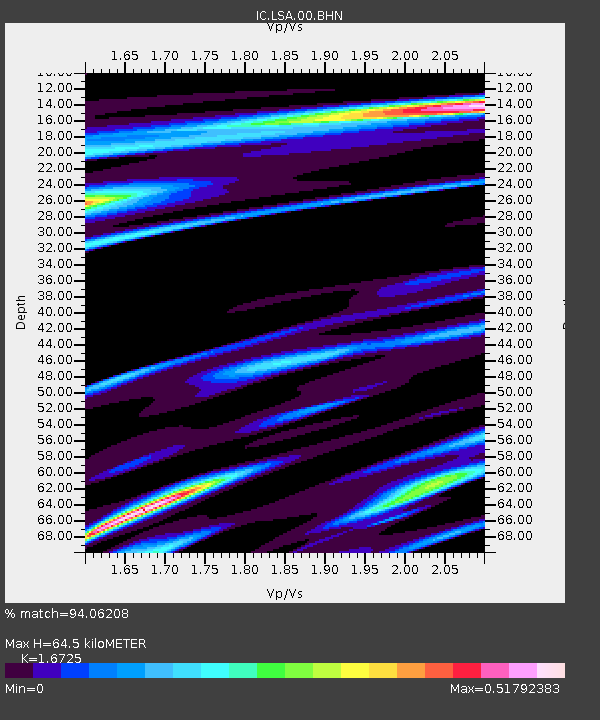
| Estimated Moho Depth: |
64.5 km |
| Estimated Crust Vp/Vs: |
1.67 |
| Assumed Crust Vp: |
6.514 km/s |
| Estimated Crust Vs: |
3.895 km/s |
| Estimated Crust Poisson's Ratio: |
0.22 |
|
| Radial Match: |
94.06208 % |
| Radial Bump: |
400 |
| Transverse Match: |
90.00797 % |
| Transverse Bump: |
400 |
| SOD ConfigId: |
2665 |
| Insert Time: |
2010-03-04 22:55:34.786 +0000 |
| GWidth: |
2.5 |
| Max Bumps: |
400 |
| Tol: |
0.001 |
|

Signal To Noise
| Channel | StoN | STA | LTA |
| IC:LSA:00:BHN:20061013T13:56:06.761002Z | 9.189202 | 1.7529305E-7 | 1.9075982E-8 |
| IC:LSA:00:BHE:20061013T13:56:06.761002Z | 11.940226 | 5.4163826E-7 | 4.536248E-8 |
| IC:LSA:00:BHZ:20061013T13:56:06.761002Z | 20.844917 | 1.1891046E-6 | 5.7045302E-8 |
| Arrivals |
| Ps | 7.1 SECOND |
| PpPs | 25 SECOND |
| PsPs/PpSs | 32 SECOND |


