You are here: Home > Network List > XD14 - Illuminating the architecture of the greater Mount St. Helens magmatic systems f Stations List
> Station MJ02 "Mount St Helens, WA" > Earthquake Result Viewer
MJ02 "Mount St Helens, WA" - Earthquake Result Viewer
| Earthquake location: |
Afghanistan-Tajikistan Bord Reg. |
| Earthquake latitude/longitude: |
36.5/71.1 |
| Earthquake time(UTC): |
2015/12/25 (359) 19:14:48 GMT |
| Earthquake Depth: |
204 km |
| Earthquake Magnitude: |
6.2 MO |
| Earthquake Catalog/Contributor: |
NEIC PDE/NEIC ALERT |
|
| Network: |
XD Illuminating the architecture of the greater Mount St. Helens magmatic systems f |
| Station: |
MJ02 "Mount St Helens, WA" |
| Lat/Lon: |
46.14 N/122.70 W |
| Elevation: |
317 m |
|
| Distance: |
96.8 deg |
| Az: |
9.64 deg |
| Baz: |
348.812 deg |
| Ray Param: |
0.04022976 |
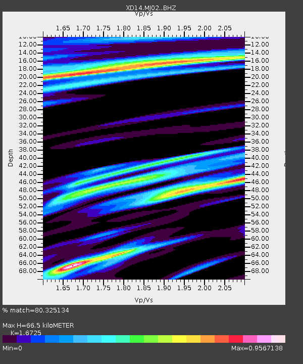
| Estimated Moho Depth: |
66.5 km |
| Estimated Crust Vp/Vs: |
1.67 |
| Assumed Crust Vp: |
6.566 km/s |
| Estimated Crust Vs: |
3.926 km/s |
| Estimated Crust Poisson's Ratio: |
0.22 |
|
| Radial Match: |
80.325134 % |
| Radial Bump: |
400 |
| Transverse Match: |
45.201023 % |
| Transverse Bump: |
367 |
| SOD ConfigId: |
7422571 |
| Insert Time: |
2019-04-21 15:50:53.047 +0000 |
| GWidth: |
2.5 |
| Max Bumps: |
400 |
| Tol: |
0.001 |
|

Signal To Noise
| Channel | StoN | STA | LTA |
| XD:MJ02: :BHZ:20151225T19:27:22.890015Z | 1.878063 | 8.613787E-7 | 4.5865272E-7 |
| XD:MJ02: :BHN:20151225T19:27:22.890015Z | 1.4764391 | 3.9207256E-7 | 2.655528E-7 |
| XD:MJ02: :BHE:20151225T19:27:22.890015Z | 1.3354113 | 5.8014655E-7 | 4.3443285E-7 |
| Arrivals |
| Ps | 7.0 SECOND |
| PpPs | 26 SECOND |
| PsPs/PpSs | 33 SECOND |


