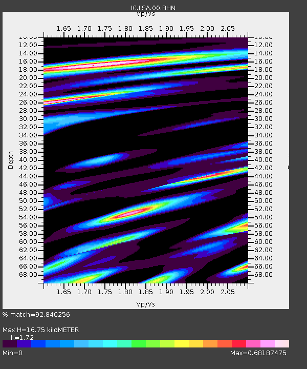
LSA Tibet, China - Earthquake Result Viewer
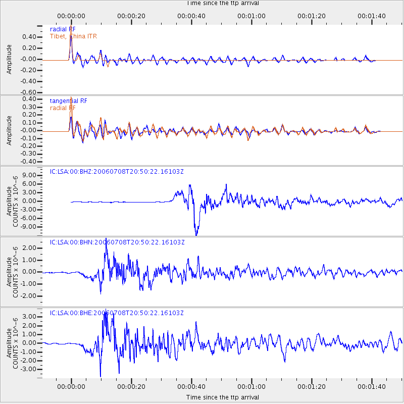
Earthquake location: Andreanof Islands, Aleutian Is.
Earthquake latitude/longitude: 51.2/-179.3
Earthquake time(UTC): 2006/07/08 (189) 20:40:00 GMT
Earthquake Depth: 22 km
Earthquake Magnitude: 6.2 MB, 6.4 MS, 6.6 MW, 6.6 MW
Earthquake Catalog/Contributor: WHDF/NEIC
Network: IC New China Digital Seismograph Network
Station: LSA Tibet, China
Lat/Lon: 29.70 N/91.15 E
Elevation: 3789 m
Distance: 67.2 deg
Az: 289.295 deg
Baz: 43.023 deg
Ray Param: 0.057091497
Estimated Moho Depth: 16.75 km
Estimated Crust Vp/Vs: 1.72
Assumed Crust Vp: 6.514 km/s
Estimated Crust Vs: 3.787 km/s
Estimated Crust Poisson's Ratio: 0.24
Radial Match: 92.840256 %
Radial Bump: 400
Transverse Match: 90.033035 %
Transverse Bump: 400
SOD ConfigId: 2665
Insert Time: 2010-03-04 22:55:48.201 +0000
GWidth: 2.5
Max Bumps: 400
Tol: 0.001

Signal To Noise

ChannelStoNSTALTA
IC:LSA:00:BHN:20060708T20:50:22.16103Z4.23116541.3628807E-73.221053E-8
IC:LSA:00:BHE:20060708T20:50:22.16103Z3.72751883.0021258E-78.0539515E-8
IC:LSA:00:BHZ:20060708T20:50:22.16103Z15.2332149.073591E-75.956452E-8
Arrivals
Ps1.9 SECOND
PpPs6.7 SECOND
PsPs/PpSs8.6 SECOND