You are here: Home > Network List > IC - New China Digital Seismograph Network Stations List
> Station LSA Tibet, China > Earthquake Result Viewer
LSA Tibet, China - Earthquake Result Viewer
| Earthquake location: |
Mid-Indian Ridge |
| Earthquake latitude/longitude: |
-36.8/78.5 |
| Earthquake time(UTC): |
2006/05/07 (127) 14:17:35 GMT |
| Earthquake Depth: |
10 km |
| Earthquake Magnitude: |
5.5 MB, 5.8 MS, 6.1 MW, 6.1 MW |
| Earthquake Catalog/Contributor: |
WHDF/NEIC |
|
| Network: |
IC New China Digital Seismograph Network |
| Station: |
LSA Tibet, China |
| Lat/Lon: |
29.70 N/91.15 E |
| Elevation: |
3789 m |
|
| Distance: |
67.2 deg |
| Az: |
11.886 deg |
| Baz: |
190.952 deg |
| Ray Param: |
0.057108067 |
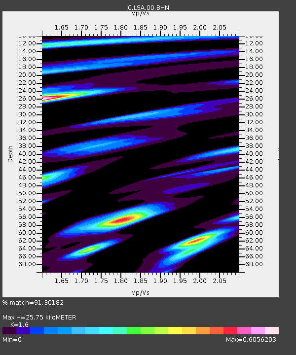
| Estimated Moho Depth: |
25.75 km |
| Estimated Crust Vp/Vs: |
1.60 |
| Assumed Crust Vp: |
6.514 km/s |
| Estimated Crust Vs: |
4.071 km/s |
| Estimated Crust Poisson's Ratio: |
0.18 |
|
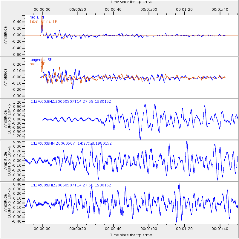
| Radial Match: |
91.30182 % |
| Radial Bump: |
400 |
| Transverse Match: |
74.50359 % |
| Transverse Bump: |
400 |
| SOD ConfigId: |
2669 |
| Insert Time: |
2010-03-04 22:56:01.572 +0000 |
| GWidth: |
2.5 |
| Max Bumps: |
400 |
| Tol: |
0.001 |
|
Signal To Noise
| Channel | StoN | STA | LTA |
| IC:LSA:00:BHN:20060507T14:27:58.198015Z | 1.6170479 | 3.7191047E-8 | 2.2999346E-8 |
| IC:LSA:00:BHE:20060507T14:27:58.198015Z | 0.9649518 | 4.31708E-8 | 4.4738815E-8 |
| IC:LSA:00:BHZ:20060507T14:27:58.198015Z | 1.8485433 | 1.4364309E-7 | 7.7706105E-8 |
| Arrivals |
| Ps | 2.5 SECOND |
| PpPs | 9.8 SECOND |
| PsPs/PpSs | 12 SECOND |


