You are here: Home > Network List > IC - New China Digital Seismograph Network Stations List
> Station LSA Tibet, China > Earthquake Result Viewer
LSA Tibet, China - Earthquake Result Viewer
| Earthquake location: |
Mid-Indian Ridge |
| Earthquake latitude/longitude: |
-38.6/78.6 |
| Earthquake time(UTC): |
2006/05/06 (126) 18:26:50 GMT |
| Earthquake Depth: |
10 km |
| Earthquake Magnitude: |
5.3 MB, 5.3 MS, 6.0 MW, 5.9 MW |
| Earthquake Catalog/Contributor: |
WHDF/NEIC |
|
| Network: |
IC New China Digital Seismograph Network |
| Station: |
LSA Tibet, China |
| Lat/Lon: |
29.70 N/91.15 E |
| Elevation: |
3789 m |
|
| Distance: |
69.0 deg |
| Az: |
11.713 deg |
| Baz: |
190.532 deg |
| Ray Param: |
0.055952553 |
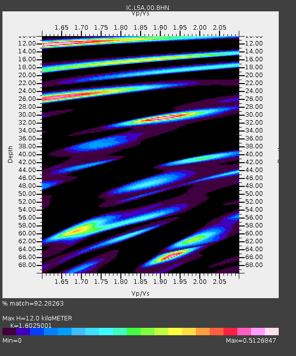
| Estimated Moho Depth: |
12.0 km |
| Estimated Crust Vp/Vs: |
1.60 |
| Assumed Crust Vp: |
6.514 km/s |
| Estimated Crust Vs: |
4.065 km/s |
| Estimated Crust Poisson's Ratio: |
0.18 |
|
| Radial Match: |
92.28263 % |
| Radial Bump: |
400 |
| Transverse Match: |
83.04897 % |
| Transverse Bump: |
400 |
| SOD ConfigId: |
2669 |
| Insert Time: |
2010-03-04 22:56:04.969 +0000 |
| GWidth: |
2.5 |
| Max Bumps: |
400 |
| Tol: |
0.001 |
|
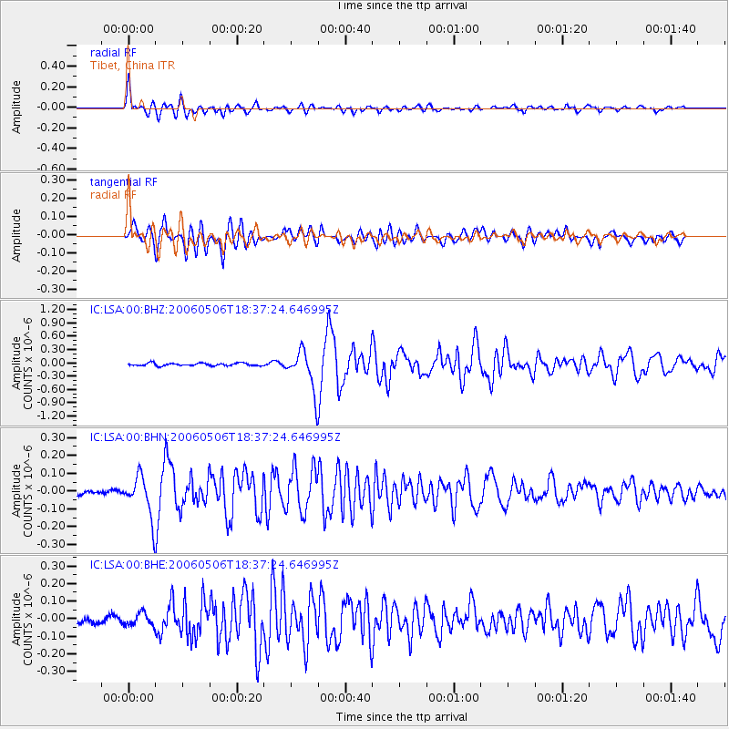
Signal To Noise
| Channel | StoN | STA | LTA |
| IC:LSA:00:BHN:20060506T18:37:24.646995Z | 5.590431 | 1.1700768E-7 | 2.0929992E-8 |
| IC:LSA:00:BHE:20060506T18:37:24.646995Z | 1.2159835 | 3.5571993E-8 | 2.925368E-8 |
| IC:LSA:00:BHZ:20060506T18:37:24.646995Z | 15.158377 | 4.5054546E-7 | 2.972254E-8 |
| Arrivals |
| Ps | 1.2 SECOND |
| PpPs | 4.6 SECOND |
| PsPs/PpSs | 5.7 SECOND |


