You are here: Home > Network List > CI - Caltech Regional Seismic Network Stations List
> Station DAN Danby, California, USA > Earthquake Result Viewer
DAN Danby, California, USA - Earthquake Result Viewer
*The percent match for this event was below the threshold and hence no stack was calculated.
| Earthquake location: |
Windward Islands |
| Earthquake latitude/longitude: |
14.6/-61.4 |
| Earthquake time(UTC): |
2015/12/28 (362) 06:55:30 GMT |
| Earthquake Depth: |
153 km |
| Earthquake Magnitude: |
5.6 MWP |
| Earthquake Catalog/Contributor: |
NEIC PDE/NEIC COMCAT |
|
| Network: |
CI Caltech Regional Seismic Network |
| Station: |
DAN Danby, California, USA |
| Lat/Lon: |
34.64 N/115.38 W |
| Elevation: |
398 m |
|
| Distance: |
52.4 deg |
| Az: |
302.587 deg |
| Baz: |
98.384 deg |
| Ray Param: |
$rayparam |
*The percent match for this event was below the threshold and hence was not used in the summary stack. |
|
| Radial Match: |
51.638653 % |
| Radial Bump: |
400 |
| Transverse Match: |
57.10483 % |
| Transverse Bump: |
400 |
| SOD ConfigId: |
7422571 |
| Insert Time: |
2019-04-21 15:54:45.031 +0000 |
| GWidth: |
2.5 |
| Max Bumps: |
400 |
| Tol: |
0.001 |
|
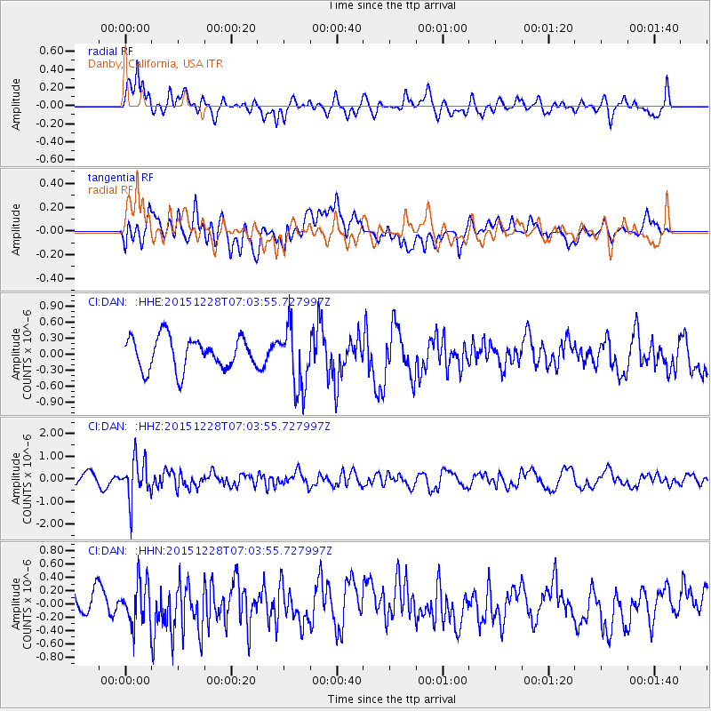
Signal To Noise
| Channel | StoN | STA | LTA |
| CI:DAN: :HHZ:20151228T07:03:55.727997Z | 4.861105 | 8.8887987E-7 | 1.8285552E-7 |
| CI:DAN: :HHN:20151228T07:03:55.727997Z | 1.9723777 | 3.2845392E-7 | 1.665269E-7 |
| CI:DAN: :HHE:20151228T07:03:55.727997Z | 1.9816715 | 5.8748105E-7 | 2.9645736E-7 |
| Arrivals |
| Ps | |
| PpPs | |
| PsPs/PpSs | |


