You are here: Home > Network List > CI - Caltech Regional Seismic Network Stations List
> Station MPP McPhearson Peak > Earthquake Result Viewer
MPP McPhearson Peak - Earthquake Result Viewer
*The percent match for this event was below the threshold and hence no stack was calculated.
| Earthquake location: |
Windward Islands |
| Earthquake latitude/longitude: |
14.6/-61.4 |
| Earthquake time(UTC): |
2015/12/28 (362) 06:55:30 GMT |
| Earthquake Depth: |
153 km |
| Earthquake Magnitude: |
5.6 MWP |
| Earthquake Catalog/Contributor: |
NEIC PDE/NEIC COMCAT |
|
| Network: |
CI Caltech Regional Seismic Network |
| Station: |
MPP McPhearson Peak |
| Lat/Lon: |
34.89 N/119.81 W |
| Elevation: |
1739 m |
|
| Distance: |
56.0 deg |
| Az: |
302.341 deg |
| Baz: |
95.723 deg |
| Ray Param: |
$rayparam |
*The percent match for this event was below the threshold and hence was not used in the summary stack. |
|
| Radial Match: |
67.98096 % |
| Radial Bump: |
400 |
| Transverse Match: |
70.19033 % |
| Transverse Bump: |
400 |
| SOD ConfigId: |
7422571 |
| Insert Time: |
2019-04-21 15:55:00.401 +0000 |
| GWidth: |
2.5 |
| Max Bumps: |
400 |
| Tol: |
0.001 |
|
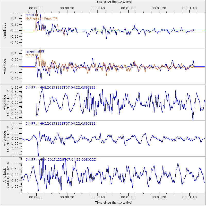
Signal To Noise
| Channel | StoN | STA | LTA |
| CI:MPP: :HHZ:20151228T07:04:22.098022Z | 2.2328823 | 1.0773372E-6 | 4.824872E-7 |
| CI:MPP: :HHN:20151228T07:04:22.098022Z | 1.9983466 | 7.203814E-7 | 3.6048874E-7 |
| CI:MPP: :HHE:20151228T07:04:22.098022Z | 1.1420146 | 5.8246485E-7 | 5.1003275E-7 |
| Arrivals |
| Ps | |
| PpPs | |
| PsPs/PpSs | |


