You are here: Home > Network List > CI - Caltech Regional Seismic Network Stations List
> Station TIN Tinemaha, Big Pine, CA, USA > Earthquake Result Viewer
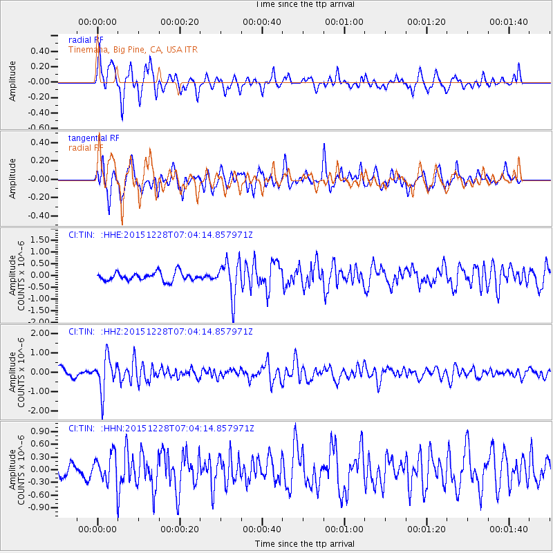
TIN Tinemaha, Big Pine, CA, USA - Earthquake Result Viewer
*The percent match for this event was below the threshold and hence no stack was calculated.
| Earthquake location: |
Windward Islands |
| Earthquake latitude/longitude: |
14.6/-61.4 |
| Earthquake time(UTC): |
2015/12/28 (362) 06:55:30 GMT |
| Earthquake Depth: |
153 km |
| Earthquake Magnitude: |
5.6 MWP |
| Earthquake Catalog/Contributor: |
NEIC PDE/NEIC COMCAT |
|
| Network: |
CI Caltech Regional Seismic Network |
| Station: |
TIN Tinemaha, Big Pine, CA, USA |
| Lat/Lon: |
37.05 N/118.23 W |
| Elevation: |
1197 m |
|
| Distance: |
55.0 deg |
| Az: |
305.133 deg |
| Baz: |
98.231 deg |
| Ray Param: |
$rayparam |
*The percent match for this event was below the threshold and hence was not used in the summary stack. |
|
| Radial Match: |
64.30293 % |
| Radial Bump: |
400 |
| Transverse Match: |
63.352436 % |
| Transverse Bump: |
400 |
| SOD ConfigId: |
7422571 |
| Insert Time: |
2019-04-21 15:55:17.359 +0000 |
| GWidth: |
2.5 |
| Max Bumps: |
400 |
| Tol: |
0.001 |
|
Signal To Noise
| Channel | StoN | STA | LTA |
| CI:TIN: :HHZ:20151228T07:04:14.857971Z | 3.1913524 | 8.8603656E-7 | 2.776367E-7 |
| CI:TIN: :HHN:20151228T07:04:14.857971Z | 1.6819563 | 3.5951683E-7 | 2.137492E-7 |
| CI:TIN: :HHE:20151228T07:04:14.857971Z | 4.3064218 | 7.8020696E-7 | 1.8117291E-7 |
| Arrivals |
| Ps | |
| PpPs | |
| PsPs/PpSs | |


