You are here: Home > Network List > IC - New China Digital Seismograph Network Stations List
> Station LSA Tibet, China > Earthquake Result Viewer
LSA Tibet, China - Earthquake Result Viewer
| Earthquake location: |
Mariana Islands Region |
| Earthquake latitude/longitude: |
20.8/146.2 |
| Earthquake time(UTC): |
2006/02/14 (045) 15:27:23 GMT |
| Earthquake Depth: |
40 km |
| Earthquake Magnitude: |
6.2 MB, 6.1 MS, 6.3 MW, 6.2 MW |
| Earthquake Catalog/Contributor: |
WHDF/NEIC |
|
| Network: |
IC New China Digital Seismograph Network |
| Station: |
LSA Tibet, China |
| Lat/Lon: |
29.70 N/91.15 E |
| Elevation: |
3789 m |
|
| Distance: |
50.2 deg |
| Az: |
291.784 deg |
| Baz: |
86.779 deg |
| Ray Param: |
0.06815493 |
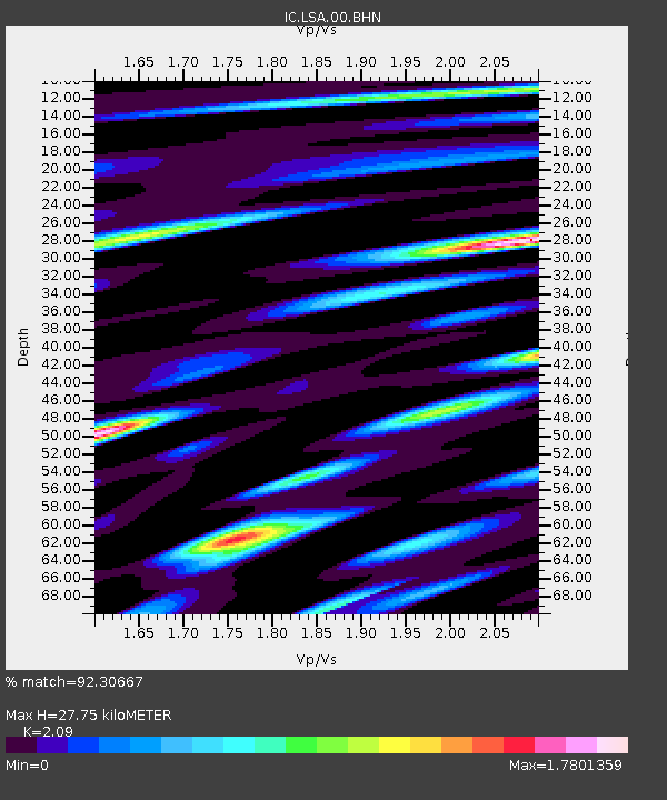
| Estimated Moho Depth: |
27.75 km |
| Estimated Crust Vp/Vs: |
2.09 |
| Assumed Crust Vp: |
6.514 km/s |
| Estimated Crust Vs: |
3.117 km/s |
| Estimated Crust Poisson's Ratio: |
0.35 |
|
| Radial Match: |
92.30667 % |
| Radial Bump: |
400 |
| Transverse Match: |
81.487175 % |
| Transverse Bump: |
400 |
| SOD ConfigId: |
2422 |
| Insert Time: |
2010-03-04 22:56:22.465 +0000 |
| GWidth: |
2.5 |
| Max Bumps: |
400 |
| Tol: |
0.001 |
|
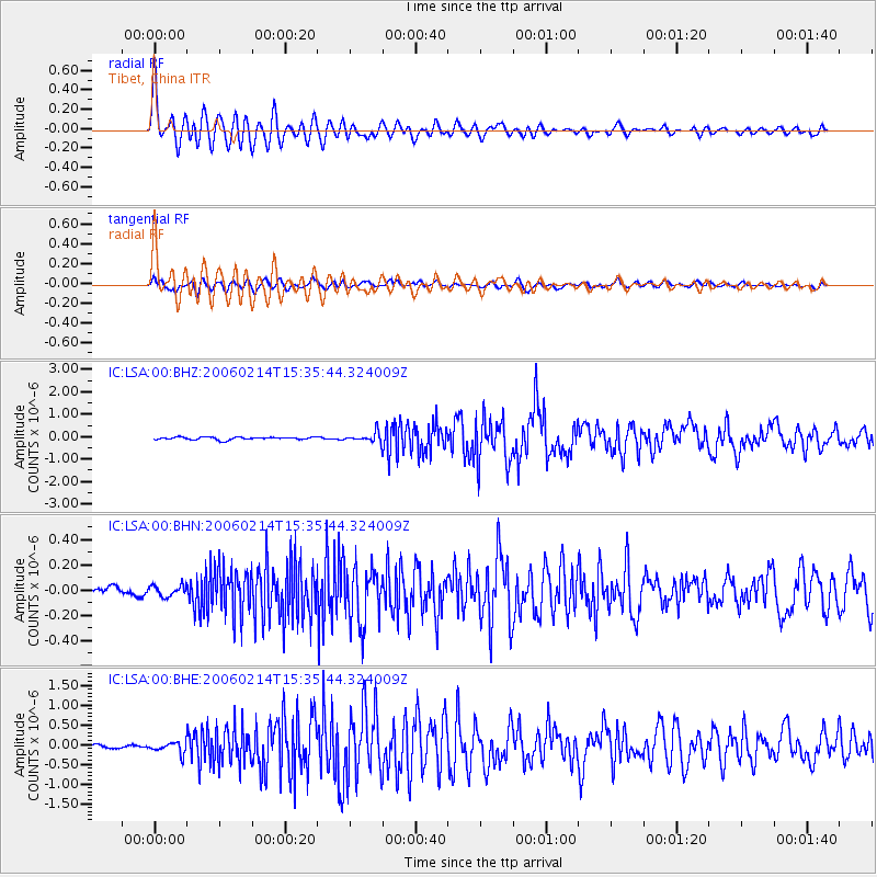
Signal To Noise
| Channel | StoN | STA | LTA |
| IC:LSA:00:BHN:20060214T15:35:44.324009Z | 1.6085554 | 4.3569123E-8 | 2.7085871E-8 |
| IC:LSA:00:BHE:20060214T15:35:44.324009Z | 3.383788 | 1.4147123E-7 | 4.1808537E-8 |
| IC:LSA:00:BHZ:20060214T15:35:44.324009Z | 3.6091423 | 2.0645199E-7 | 5.7202506E-8 |
| Arrivals |
| Ps | 4.9 SECOND |
| PpPs | 13 SECOND |
| PsPs/PpSs | 17 SECOND |


