You are here: Home > Network List > IC - New China Digital Seismograph Network Stations List
> Station LSA Tibet, China > Earthquake Result Viewer
LSA Tibet, China - Earthquake Result Viewer
| Earthquake location: |
Southern Greece |
| Earthquake latitude/longitude: |
36.3/23.2 |
| Earthquake time(UTC): |
2006/01/08 (008) 11:34:55 GMT |
| Earthquake Depth: |
66 km |
| Earthquake Magnitude: |
6.5 MB, 6.7 MW, 6.7 MW |
| Earthquake Catalog/Contributor: |
WHDF/NEIC |
|
| Network: |
IC New China Digital Seismograph Network |
| Station: |
LSA Tibet, China |
| Lat/Lon: |
29.70 N/91.15 E |
| Elevation: |
3789 m |
|
| Distance: |
56.3 deg |
| Az: |
75.704 deg |
| Baz: |
295.896 deg |
| Ray Param: |
0.06404527 |
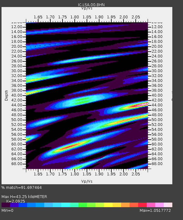
| Estimated Moho Depth: |
43.25 km |
| Estimated Crust Vp/Vs: |
2.09 |
| Assumed Crust Vp: |
6.514 km/s |
| Estimated Crust Vs: |
3.113 km/s |
| Estimated Crust Poisson's Ratio: |
0.35 |
|
| Radial Match: |
91.697464 % |
| Radial Bump: |
400 |
| Transverse Match: |
88.31638 % |
| Transverse Bump: |
400 |
| SOD ConfigId: |
4977 |
| Insert Time: |
2010-03-04 22:56:26.181 +0000 |
| GWidth: |
2.5 |
| Max Bumps: |
400 |
| Tol: |
0.001 |
|
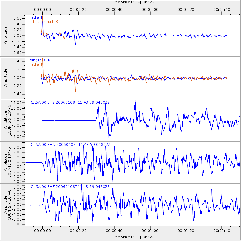
Signal To Noise
| Channel | StoN | STA | LTA |
| IC:LSA:00:BHN:20060108T11:43:59.04802Z | 29.281057 | 8.6956226E-7 | 2.9697093E-8 |
| IC:LSA:00:BHE:20060108T11:43:59.04802Z | 38.930237 | 2.3887405E-6 | 6.1359515E-8 |
| IC:LSA:00:BHZ:20060108T11:43:59.04802Z | 79.70344 | 5.425677E-6 | 6.807331E-8 |
| Arrivals |
| Ps | 7.6 SECOND |
| PpPs | 20 SECOND |
| PsPs/PpSs | 27 SECOND |


