You are here: Home > Network List > IC - New China Digital Seismograph Network Stations List
> Station LSA Tibet, China > Earthquake Result Viewer
LSA Tibet, China - Earthquake Result Viewer
| Earthquake location: |
Mid-Indian Ridge |
| Earthquake latitude/longitude: |
-40.1/78.5 |
| Earthquake time(UTC): |
2006/03/06 (065) 18:13:08 GMT |
| Earthquake Depth: |
10 km |
| Earthquake Magnitude: |
5.5 MB, 6.1 MS, 6.2 MW, 6.1 MW |
| Earthquake Catalog/Contributor: |
WHDF/NEIC |
|
| Network: |
IC New China Digital Seismograph Network |
| Station: |
LSA Tibet, China |
| Lat/Lon: |
29.70 N/91.15 E |
| Elevation: |
3789 m |
|
| Distance: |
70.4 deg |
| Az: |
11.679 deg |
| Baz: |
190.28 deg |
| Ray Param: |
0.054982733 |
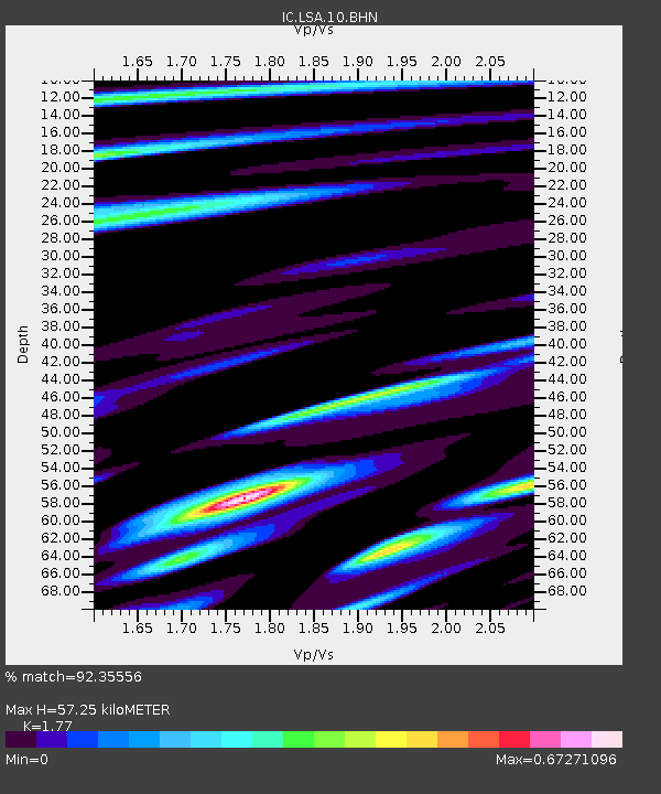
| Estimated Moho Depth: |
57.25 km |
| Estimated Crust Vp/Vs: |
1.77 |
| Assumed Crust Vp: |
6.514 km/s |
| Estimated Crust Vs: |
3.68 km/s |
| Estimated Crust Poisson's Ratio: |
0.27 |
|
| Radial Match: |
92.35556 % |
| Radial Bump: |
400 |
| Transverse Match: |
82.09979 % |
| Transverse Bump: |
400 |
| SOD ConfigId: |
83759 |
| Insert Time: |
2010-03-04 22:56:32.483 +0000 |
| GWidth: |
2.5 |
| Max Bumps: |
400 |
| Tol: |
0.001 |
|
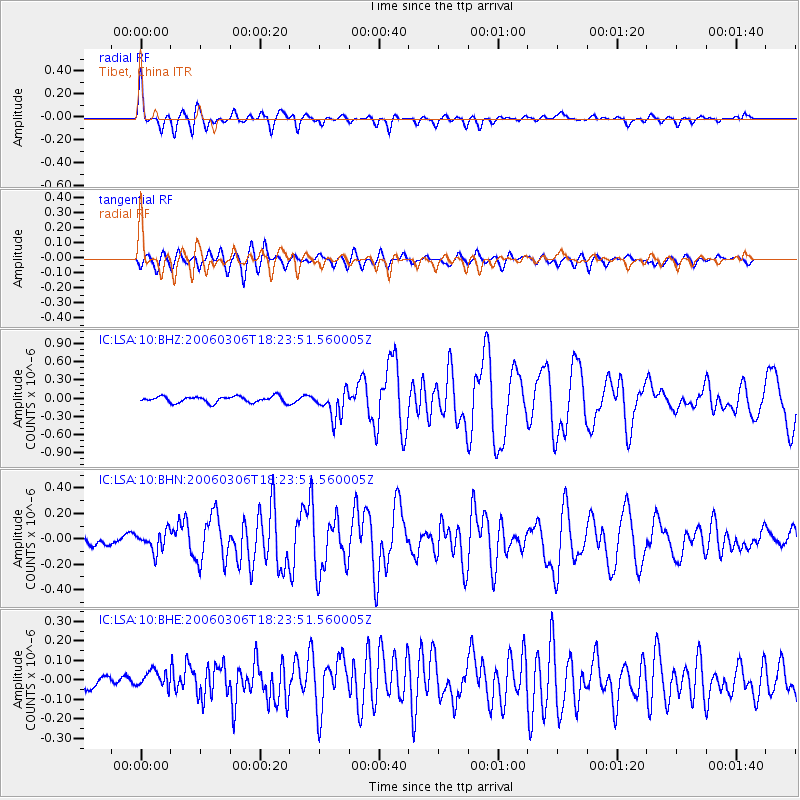
Signal To Noise
| Channel | StoN | STA | LTA |
| IC:LSA:10:BHN:20060306T18:23:51.560005Z | 2.2847836 | 7.841088E-8 | 3.431873E-8 |
| IC:LSA:10:BHE:20060306T18:23:51.560005Z | 1.5145469 | 5.1412513E-8 | 3.3945803E-8 |
| IC:LSA:10:BHZ:20060306T18:23:51.560005Z | 4.4455624 | 2.26543E-7 | 5.0959354E-8 |
| Arrivals |
| Ps | 7.0 SECOND |
| PpPs | 23 SECOND |
| PsPs/PpSs | 30 SECOND |


