You are here: Home > Network List > IC - New China Digital Seismograph Network Stations List
> Station LSA Tibet, China > Earthquake Result Viewer
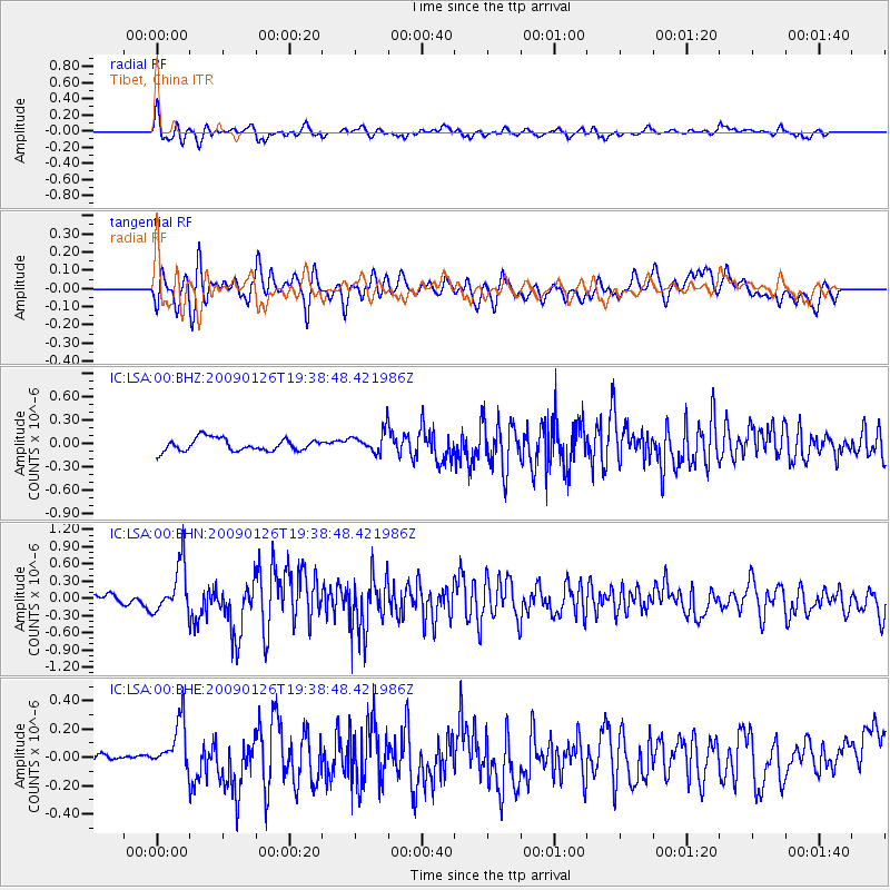
LSA Tibet, China - Earthquake Result Viewer
*The percent match for this event was below the threshold and hence no stack was calculated.
| Earthquake location: |
Southern Sumatra, Indonesia |
| Earthquake latitude/longitude: |
-0.4/98.2 |
| Earthquake time(UTC): |
2009/01/26 (026) 19:33:04 GMT |
| Earthquake Depth: |
10 km |
| Earthquake Magnitude: |
5.6 MW, 5.4 MB |
| Earthquake Catalog/Contributor: |
WHDF/NEIC |
|
| Network: |
IC New China Digital Seismograph Network |
| Station: |
LSA Tibet, China |
| Lat/Lon: |
29.70 N/91.15 E |
| Elevation: |
3789 m |
|
| Distance: |
30.6 deg |
| Az: |
347.929 deg |
| Baz: |
166.092 deg |
| Ray Param: |
$rayparam |
*The percent match for this event was below the threshold and hence was not used in the summary stack. |
|
| Radial Match: |
75.00857 % |
| Radial Bump: |
400 |
| Transverse Match: |
65.511024 % |
| Transverse Bump: |
400 |
| SOD ConfigId: |
2658 |
| Insert Time: |
2010-03-04 22:56:50.629 +0000 |
| GWidth: |
2.5 |
| Max Bumps: |
400 |
| Tol: |
0.001 |
|
Signal To Noise
| Channel | StoN | STA | LTA |
| IC:LSA:00:BHN:20090126T19:38:48.421986Z | 6.5659494 | 4.357615E-7 | 6.636687E-8 |
| IC:LSA:00:BHE:20090126T19:38:48.421986Z | 3.9092903 | 1.7974457E-7 | 4.5978823E-8 |
| IC:LSA:00:BHZ:20090126T19:38:48.421986Z | 1.5766289 | 1.2665873E-7 | 8.033516E-8 |
| Arrivals |
| Ps | |
| PpPs | |
| PsPs/PpSs | |


