You are here: Home > Network List > IC - New China Digital Seismograph Network Stations List
> Station LSA Tibet, China > Earthquake Result Viewer
LSA Tibet, China - Earthquake Result Viewer
*The percent match for this event was below the threshold and hence no stack was calculated.
| Earthquake location: |
Southern Sumatra, Indonesia |
| Earthquake latitude/longitude: |
-0.3/98.3 |
| Earthquake time(UTC): |
2009/01/28 (028) 00:01:13 GMT |
| Earthquake Depth: |
14 km |
| Earthquake Magnitude: |
5.7 MB, 5.6 MS, 5.7 MW, 5.7 MW |
| Earthquake Catalog/Contributor: |
WHDF/NEIC |
|
| Network: |
IC New China Digital Seismograph Network |
| Station: |
LSA Tibet, China |
| Lat/Lon: |
29.70 N/91.15 E |
| Elevation: |
3789 m |
|
| Distance: |
30.6 deg |
| Az: |
347.749 deg |
| Baz: |
165.884 deg |
| Ray Param: |
$rayparam |
*The percent match for this event was below the threshold and hence was not used in the summary stack. |
|
| Radial Match: |
78.061356 % |
| Radial Bump: |
400 |
| Transverse Match: |
70.230484 % |
| Transverse Bump: |
400 |
| SOD ConfigId: |
2658 |
| Insert Time: |
2010-03-04 22:56:52.617 +0000 |
| GWidth: |
2.5 |
| Max Bumps: |
400 |
| Tol: |
0.001 |
|
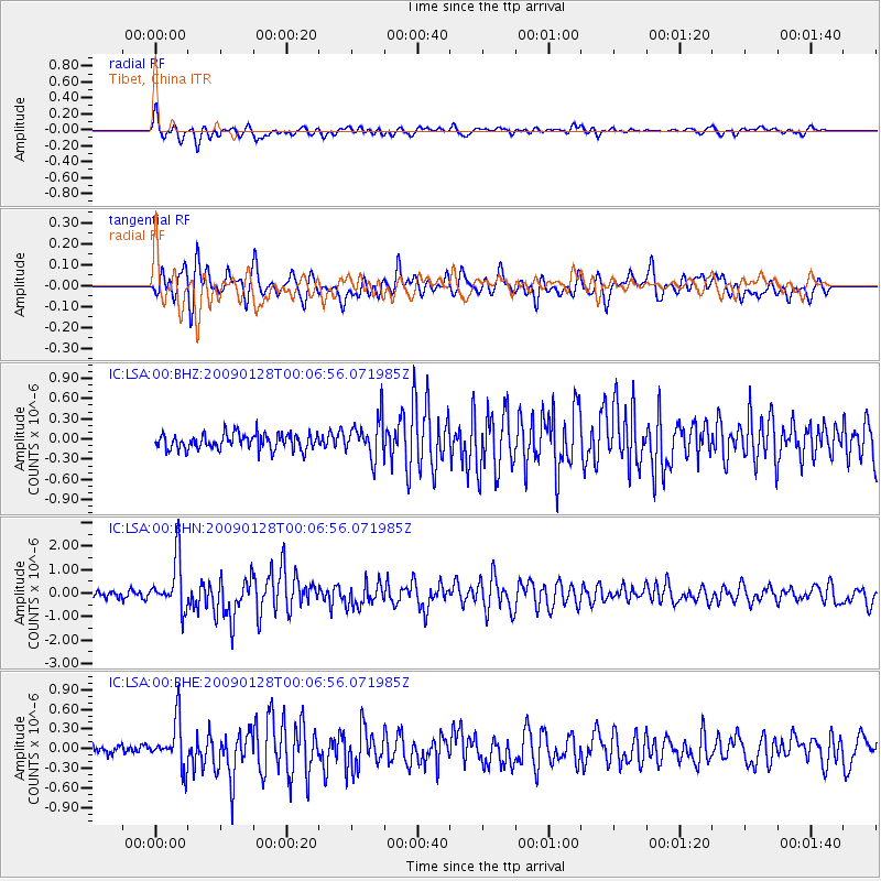
Signal To Noise
| Channel | StoN | STA | LTA |
| IC:LSA:00:BHN:20090128T00:06:56.071985Z | 6.3853183 | 1.0715986E-6 | 1.6782228E-7 |
| IC:LSA:00:BHE:20090128T00:06:56.071985Z | 6.908576 | 3.501289E-7 | 5.0680324E-8 |
| IC:LSA:00:BHZ:20090128T00:06:56.071985Z | 2.5531878 | 2.8980236E-7 | 1.1350609E-7 |
| Arrivals |
| Ps | |
| PpPs | |
| PsPs/PpSs | |


