You are here: Home > Network List > TA - USArray Transportable Network (new EarthScope stations) Stations List
> Station 121A Cookes Peak, Deming, NM, USA > Earthquake Result Viewer
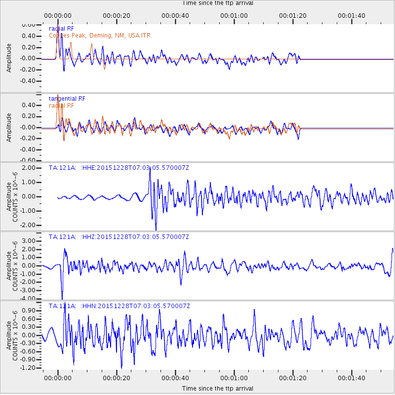
121A Cookes Peak, Deming, NM, USA - Earthquake Result Viewer
*The percent match for this event was below the threshold and hence no stack was calculated.
| Earthquake location: |
Windward Islands |
| Earthquake latitude/longitude: |
14.6/-61.4 |
| Earthquake time(UTC): |
2015/12/28 (362) 06:55:30 GMT |
| Earthquake Depth: |
153 km |
| Earthquake Magnitude: |
5.6 MWP |
| Earthquake Catalog/Contributor: |
NEIC PDE/NEIC COMCAT |
|
| Network: |
TA USArray Transportable Network (new EarthScope stations) |
| Station: |
121A Cookes Peak, Deming, NM, USA |
| Lat/Lon: |
32.53 N/107.79 W |
| Elevation: |
1652 m |
|
| Distance: |
45.7 deg |
| Az: |
301.322 deg |
| Baz: |
101.741 deg |
| Ray Param: |
$rayparam |
*The percent match for this event was below the threshold and hence was not used in the summary stack. |
|
| Radial Match: |
67.06604 % |
| Radial Bump: |
400 |
| Transverse Match: |
62.75384 % |
| Transverse Bump: |
400 |
| SOD ConfigId: |
7422571 |
| Insert Time: |
2019-04-21 16:00:38.954 +0000 |
| GWidth: |
2.5 |
| Max Bumps: |
400 |
| Tol: |
0.001 |
|
Signal To Noise
| Channel | StoN | STA | LTA |
| TA:121A: :HHZ:20151228T07:03:05.570007Z | 8.701183 | 1.3037939E-6 | 1.4984097E-7 |
| TA:121A: :HHN:20151228T07:03:05.570007Z | 3.2120473 | 4.7663931E-7 | 1.4839112E-7 |
| TA:121A: :HHE:20151228T07:03:05.570007Z | 9.675338 | 9.928139E-7 | 1.0261283E-7 |
| Arrivals |
| Ps | |
| PpPs | |
| PsPs/PpSs | |


