You are here: Home > Network List > TA - USArray Transportable Network (new EarthScope stations) Stations List
> Station A36M Sachs Harbour, NT, CAN > Earthquake Result Viewer
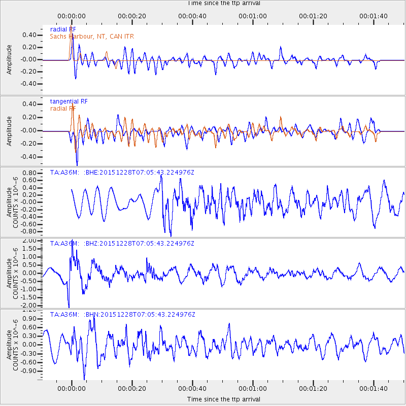
A36M Sachs Harbour, NT, CAN - Earthquake Result Viewer
*The percent match for this event was below the threshold and hence no stack was calculated.
| Earthquake location: |
Windward Islands |
| Earthquake latitude/longitude: |
14.6/-61.4 |
| Earthquake time(UTC): |
2015/12/28 (362) 06:55:30 GMT |
| Earthquake Depth: |
153 km |
| Earthquake Magnitude: |
5.6 MWP |
| Earthquake Catalog/Contributor: |
NEIC PDE/NEIC COMCAT |
|
| Network: |
TA USArray Transportable Network (new EarthScope stations) |
| Station: |
A36M Sachs Harbour, NT, CAN |
| Lat/Lon: |
71.99 N/125.25 W |
| Elevation: |
32 m |
|
| Distance: |
68.2 deg |
| Az: |
342.498 deg |
| Baz: |
110.63 deg |
| Ray Param: |
$rayparam |
*The percent match for this event was below the threshold and hence was not used in the summary stack. |
|
| Radial Match: |
67.36531 % |
| Radial Bump: |
400 |
| Transverse Match: |
75.438 % |
| Transverse Bump: |
400 |
| SOD ConfigId: |
7422571 |
| Insert Time: |
2019-04-21 16:00:39.638 +0000 |
| GWidth: |
2.5 |
| Max Bumps: |
400 |
| Tol: |
0.001 |
|
Signal To Noise
| Channel | StoN | STA | LTA |
| TA:A36M: :BHZ:20151228T07:05:43.224976Z | 3.3784153 | 1.0180194E-6 | 3.0133043E-7 |
| TA:A36M: :BHN:20151228T07:05:43.224976Z | 1.501636 | 4.4743507E-7 | 2.9796504E-7 |
| TA:A36M: :BHE:20151228T07:05:43.224976Z | 2.024847 | 4.8759995E-7 | 2.408083E-7 |
| Arrivals |
| Ps | |
| PpPs | |
| PsPs/PpSs | |


