You are here: Home > Network List > TA - USArray Transportable Network (new EarthScope stations) Stations List
> Station MDND Maddock, ND, USA > Earthquake Result Viewer
MDND Maddock, ND, USA - Earthquake Result Viewer
*The percent match for this event was below the threshold and hence no stack was calculated.
| Earthquake location: |
Windward Islands |
| Earthquake latitude/longitude: |
14.6/-61.4 |
| Earthquake time(UTC): |
2015/12/28 (362) 06:55:30 GMT |
| Earthquake Depth: |
153 km |
| Earthquake Magnitude: |
5.6 MWP |
| Earthquake Catalog/Contributor: |
NEIC PDE/NEIC COMCAT |
|
| Network: |
TA USArray Transportable Network (new EarthScope stations) |
| Station: |
MDND Maddock, ND, USA |
| Lat/Lon: |
47.85 N/99.60 W |
| Elevation: |
479 m |
|
| Distance: |
45.8 deg |
| Az: |
324.441 deg |
| Baz: |
123.293 deg |
| Ray Param: |
$rayparam |
*The percent match for this event was below the threshold and hence was not used in the summary stack. |
|
| Radial Match: |
64.43735 % |
| Radial Bump: |
344 |
| Transverse Match: |
56.67316 % |
| Transverse Bump: |
400 |
| SOD ConfigId: |
7422571 |
| Insert Time: |
2019-04-21 16:01:05.467 +0000 |
| GWidth: |
2.5 |
| Max Bumps: |
400 |
| Tol: |
0.001 |
|
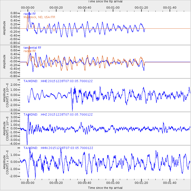
Signal To Noise
| Channel | StoN | STA | LTA |
| TA:MDND: :HHZ:20151228T07:03:05.700012Z | 4.9600973 | 1.7257872E-6 | 3.4793416E-7 |
| TA:MDND: :HHN:20151228T07:03:05.700012Z | 1.5129728 | 1.0954861E-6 | 7.24062E-7 |
| TA:MDND: :HHE:20151228T07:03:05.700012Z | 2.0951505 | 1.1394668E-6 | 5.4385924E-7 |
| Arrivals |
| Ps | |
| PpPs | |
| PsPs/PpSs | |


