You are here: Home > Network List > TA - USArray Transportable Network (new EarthScope stations) Stations List
> Station R11A Troy Canyon, Currant, NV, USA > Earthquake Result Viewer
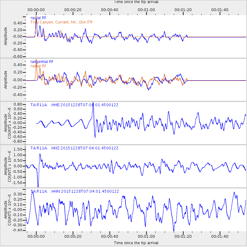
R11A Troy Canyon, Currant, NV, USA - Earthquake Result Viewer
*The percent match for this event was below the threshold and hence no stack was calculated.
| Earthquake location: |
Windward Islands |
| Earthquake latitude/longitude: |
14.6/-61.4 |
| Earthquake time(UTC): |
2015/12/28 (362) 06:55:30 GMT |
| Earthquake Depth: |
153 km |
| Earthquake Magnitude: |
5.6 MWP |
| Earthquake Catalog/Contributor: |
NEIC PDE/NEIC COMCAT |
|
| Network: |
TA USArray Transportable Network (new EarthScope stations) |
| Station: |
R11A Troy Canyon, Currant, NV, USA |
| Lat/Lon: |
38.35 N/115.59 W |
| Elevation: |
1756 m |
|
| Distance: |
53.1 deg |
| Az: |
307.14 deg |
| Baz: |
101.02 deg |
| Ray Param: |
$rayparam |
*The percent match for this event was below the threshold and hence was not used in the summary stack. |
|
| Radial Match: |
65.35072 % |
| Radial Bump: |
400 |
| Transverse Match: |
56.686092 % |
| Transverse Bump: |
400 |
| SOD ConfigId: |
7422571 |
| Insert Time: |
2019-04-21 16:01:16.424 +0000 |
| GWidth: |
2.5 |
| Max Bumps: |
400 |
| Tol: |
0.001 |
|
Signal To Noise
| Channel | StoN | STA | LTA |
| TA:R11A: :HHZ:20151228T07:04:01.450012Z | 6.3700852 | 7.210626E-7 | 1.13195114E-7 |
| TA:R11A: :HHN:20151228T07:04:01.450012Z | 0.75292647 | 1.2887776E-7 | 1.711691E-7 |
| TA:R11A: :HHE:20151228T07:04:01.450012Z | 4.3493767 | 3.696301E-7 | 8.498461E-8 |
| Arrivals |
| Ps | |
| PpPs | |
| PsPs/PpSs | |


