You are here: Home > Network List > TA - USArray Transportable Network (new EarthScope stations) Stations List
> Station W39A Magazine, AR, USA > Earthquake Result Viewer
W39A Magazine, AR, USA - Earthquake Result Viewer
*The percent match for this event was below the threshold and hence no stack was calculated.
| Earthquake location: |
Windward Islands |
| Earthquake latitude/longitude: |
14.6/-61.4 |
| Earthquake time(UTC): |
2015/12/28 (362) 06:55:30 GMT |
| Earthquake Depth: |
153 km |
| Earthquake Magnitude: |
5.6 MWP |
| Earthquake Catalog/Contributor: |
NEIC PDE/NEIC COMCAT |
|
| Network: |
TA USArray Transportable Network (new EarthScope stations) |
| Station: |
W39A Magazine, AR, USA |
| Lat/Lon: |
35.20 N/93.78 W |
| Elevation: |
162 m |
|
| Distance: |
35.6 deg |
| Az: |
311.058 deg |
| Baz: |
116.956 deg |
| Ray Param: |
$rayparam |
*The percent match for this event was below the threshold and hence was not used in the summary stack. |
|
| Radial Match: |
61.679855 % |
| Radial Bump: |
400 |
| Transverse Match: |
52.98927 % |
| Transverse Bump: |
400 |
| SOD ConfigId: |
7422571 |
| Insert Time: |
2019-04-21 16:01:23.467 +0000 |
| GWidth: |
2.5 |
| Max Bumps: |
400 |
| Tol: |
0.001 |
|
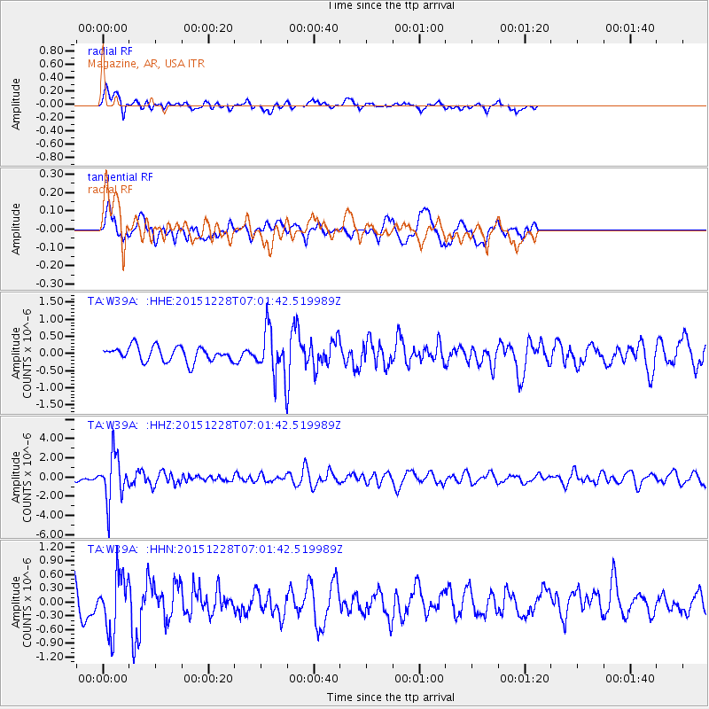
Signal To Noise
| Channel | StoN | STA | LTA |
| TA:W39A: :HHZ:20151228T07:01:42.519989Z | 6.924569 | 2.3890939E-6 | 3.4501699E-7 |
| TA:W39A: :HHN:20151228T07:01:42.519989Z | 2.74998 | 6.192142E-7 | 2.2517044E-7 |
| TA:W39A: :HHE:20151228T07:01:42.519989Z | 3.4778929 | 7.518008E-7 | 2.161656E-7 |
| Arrivals |
| Ps | |
| PpPs | |
| PsPs/PpSs | |


