You are here: Home > Network List > IC - New China Digital Seismograph Network Stations List
> Station LSA Tibet, China > Earthquake Result Viewer
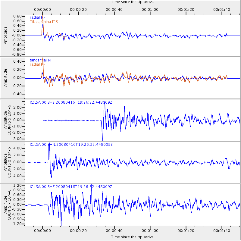
LSA Tibet, China - Earthquake Result Viewer
*The percent match for this event was below the threshold and hence no stack was calculated.
| Earthquake location: |
Eastern Honshu, Japan |
| Earthquake latitude/longitude: |
39.0/140.0 |
| Earthquake time(UTC): |
2008/04/16 (107) 19:19:36 GMT |
| Earthquake Depth: |
166 km |
| Earthquake Magnitude: |
5.6 MB, 5.8 MW, 5.8 MW |
| Earthquake Catalog/Contributor: |
WHDF/NEIC |
|
| Network: |
IC New China Digital Seismograph Network |
| Station: |
LSA Tibet, China |
| Lat/Lon: |
29.70 N/91.15 E |
| Elevation: |
3789 m |
|
| Distance: |
41.0 deg |
| Az: |
272.18 deg |
| Baz: |
63.455 deg |
| Ray Param: |
$rayparam |
*The percent match for this event was below the threshold and hence was not used in the summary stack. |
|
| Radial Match: |
64.205124 % |
| Radial Bump: |
400 |
| Transverse Match: |
62.88042 % |
| Transverse Bump: |
400 |
| SOD ConfigId: |
2504 |
| Insert Time: |
2010-03-04 22:57:43.406 +0000 |
| GWidth: |
2.5 |
| Max Bumps: |
400 |
| Tol: |
0.001 |
|
Signal To Noise
| Channel | StoN | STA | LTA |
| IC:LSA:00:BHN:20080416T19:26:32.448009Z | 37.42642 | 2.0619889E-6 | 5.509448E-8 |
| IC:LSA:00:BHE:20080416T19:26:32.448009Z | 10.303848 | 2.2525876E-7 | 2.1861615E-8 |
| IC:LSA:00:BHZ:20080416T19:26:32.448009Z | 34.17753 | 1.2519748E-6 | 3.663152E-8 |
| Arrivals |
| Ps | |
| PpPs | |
| PsPs/PpSs | |


