You are here: Home > Network List > IC - New China Digital Seismograph Network Stations List
> Station LSA Tibet, China > Earthquake Result Viewer
LSA Tibet, China - Earthquake Result Viewer
*The percent match for this event was below the threshold and hence no stack was calculated.
| Earthquake location: |
Southeast Of Honshu, Japan |
| Earthquake latitude/longitude: |
30.2/138.8 |
| Earthquake time(UTC): |
2008/10/01 (275) 09:38:12 GMT |
| Earthquake Depth: |
414 km |
| Earthquake Magnitude: |
5.7 MW, 5.1 MB, 5.7 MW |
| Earthquake Catalog/Contributor: |
WHDF/NEIC |
|
| Network: |
IC New China Digital Seismograph Network |
| Station: |
LSA Tibet, China |
| Lat/Lon: |
29.70 N/91.15 E |
| Elevation: |
3789 m |
|
| Distance: |
41.0 deg |
| Az: |
281.755 deg |
| Baz: |
77.036 deg |
| Ray Param: |
$rayparam |
*The percent match for this event was below the threshold and hence was not used in the summary stack. |
|
| Radial Match: |
66.316284 % |
| Radial Bump: |
400 |
| Transverse Match: |
65.19892 % |
| Transverse Bump: |
400 |
| SOD ConfigId: |
2556 |
| Insert Time: |
2010-03-04 22:58:07.720 +0000 |
| GWidth: |
2.5 |
| Max Bumps: |
400 |
| Tol: |
0.001 |
|
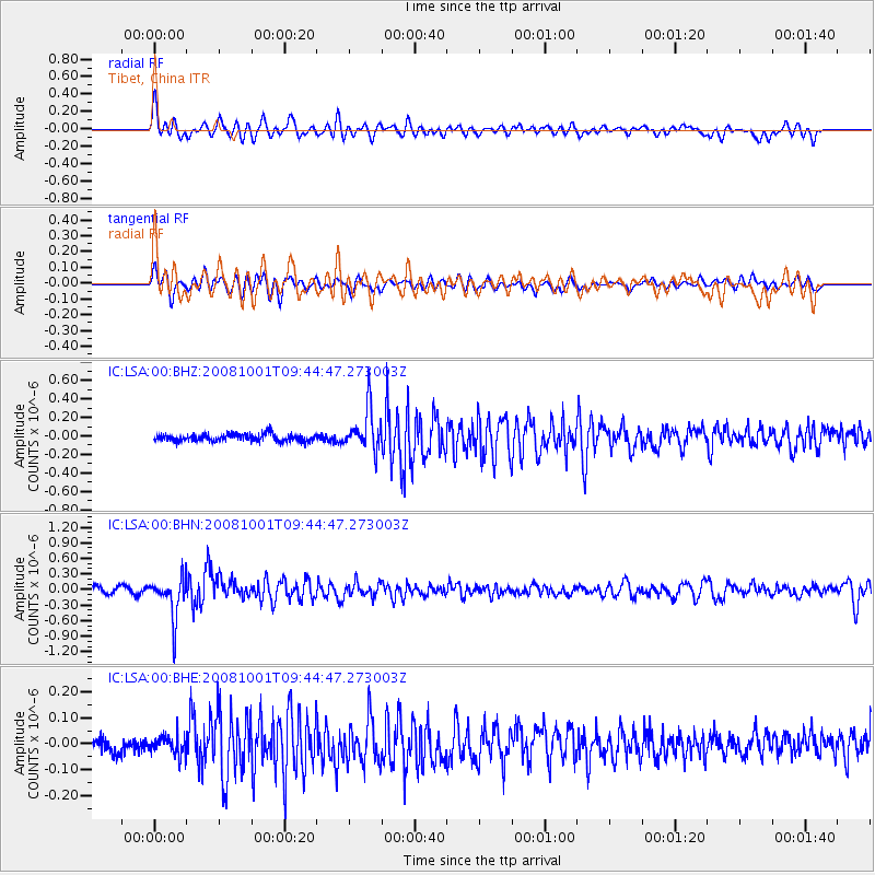
Signal To Noise
| Channel | StoN | STA | LTA |
| IC:LSA:00:BHN:20081001T09:44:47.273003Z | 6.4592505 | 3.9162666E-7 | 6.0630356E-8 |
| IC:LSA:00:BHE:20081001T09:44:47.273003Z | 1.4492526 | 3.8098616E-8 | 2.6288458E-8 |
| IC:LSA:00:BHZ:20081001T09:44:47.273003Z | 5.660457 | 2.214852E-7 | 3.91285E-8 |
| Arrivals |
| Ps | |
| PpPs | |
| PsPs/PpSs | |


