You are here: Home > Network List > CI - Caltech Regional Seismic Network Stations List
> Station SWS Sam W. Stewart, Westmorland, CA, USA > Earthquake Result Viewer
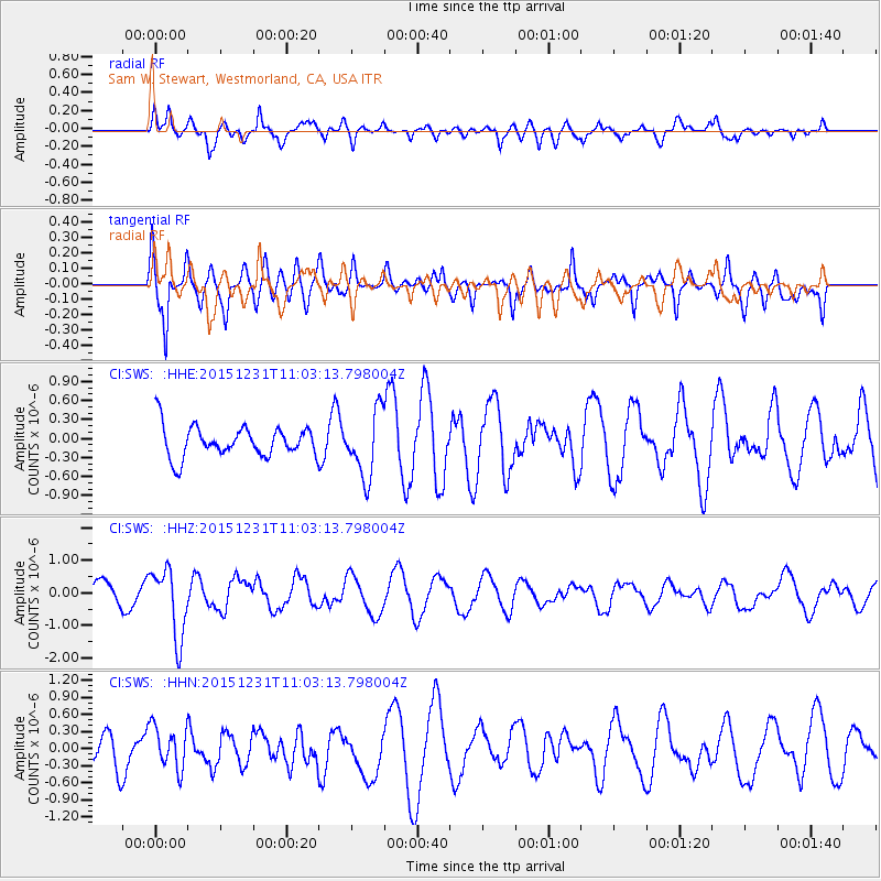
SWS Sam W. Stewart, Westmorland, CA, USA - Earthquake Result Viewer
*The percent match for this event was below the threshold and hence no stack was calculated.
| Earthquake location: |
Near Coast Of Nicaragua |
| Earthquake latitude/longitude: |
11.2/-86.6 |
| Earthquake time(UTC): |
2015/12/31 (365) 10:57:00 GMT |
| Earthquake Depth: |
36 km |
| Earthquake Magnitude: |
5.7 MB |
| Earthquake Catalog/Contributor: |
NEIC PDE/NEIC COMCAT |
|
| Network: |
CI Caltech Regional Seismic Network |
| Station: |
SWS Sam W. Stewart, Westmorland, CA, USA |
| Lat/Lon: |
32.94 N/115.80 W |
| Elevation: |
140 m |
|
| Distance: |
34.4 deg |
| Az: |
313.564 deg |
| Baz: |
122.265 deg |
| Ray Param: |
$rayparam |
*The percent match for this event was below the threshold and hence was not used in the summary stack. |
|
| Radial Match: |
67.66328 % |
| Radial Bump: |
400 |
| Transverse Match: |
73.33141 % |
| Transverse Bump: |
400 |
| SOD ConfigId: |
7422571 |
| Insert Time: |
2019-04-21 16:13:06.125 +0000 |
| GWidth: |
2.5 |
| Max Bumps: |
400 |
| Tol: |
0.001 |
|
Signal To Noise
| Channel | StoN | STA | LTA |
| CI:SWS: :HHZ:20151231T11:03:13.798004Z | 3.1392345 | 1.0559913E-6 | 3.36385E-7 |
| CI:SWS: :HHN:20151231T11:03:13.798004Z | 1.1801463 | 3.6850713E-7 | 3.1225545E-7 |
| CI:SWS: :HHE:20151231T11:03:13.798004Z | 2.2692573 | 5.3743685E-7 | 2.368338E-7 |
| Arrivals |
| Ps | |
| PpPs | |
| PsPs/PpSs | |


