You are here: Home > Network List > IU - Global Seismograph Network (GSN - IRIS/USGS) Stations List
> Station FURI Mt. Furi, Ethiopia > Earthquake Result Viewer
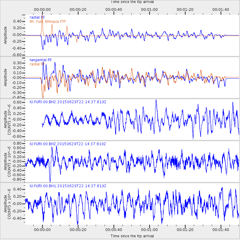
FURI Mt. Furi, Ethiopia - Earthquake Result Viewer
*The percent match for this event was below the threshold and hence no stack was calculated.
| Earthquake location: |
Afghanistan-Tajikistan Bord Reg. |
| Earthquake latitude/longitude: |
36.7/71.3 |
| Earthquake time(UTC): |
2015/06/29 (180) 22:07:48 GMT |
| Earthquake Depth: |
190 km |
| Earthquake Magnitude: |
5.5 MB |
| Earthquake Catalog/Contributor: |
NEIC PDE/NEIC ALERT |
|
| Network: |
IU Global Seismograph Network (GSN - IRIS/USGS) |
| Station: |
FURI Mt. Furi, Ethiopia |
| Lat/Lon: |
8.90 N/38.68 E |
| Elevation: |
2570 m |
|
| Distance: |
40.5 deg |
| Az: |
235.075 deg |
| Baz: |
41.83 deg |
| Ray Param: |
$rayparam |
*The percent match for this event was below the threshold and hence was not used in the summary stack. |
|
| Radial Match: |
53.571537 % |
| Radial Bump: |
400 |
| Transverse Match: |
56.730164 % |
| Transverse Bump: |
400 |
| SOD ConfigId: |
976571 |
| Insert Time: |
2015-07-13 22:24:31.909 +0000 |
| GWidth: |
2.5 |
| Max Bumps: |
400 |
| Tol: |
0.001 |
|
Signal To Noise
| Channel | StoN | STA | LTA |
| IU:FURI:00:BHZ:20150629T22:14:37.819Z | 2.6257632 | 2.989279E-7 | 1.13844195E-7 |
| IU:FURI:00:BH1:20150629T22:14:37.819Z | 1.6319145 | 1.9271974E-7 | 1.1809426E-7 |
| IU:FURI:00:BH2:20150629T22:14:37.819Z | 1.1710792 | 1.3882874E-7 | 1.18547696E-7 |
| Arrivals |
| Ps | |
| PpPs | |
| PsPs/PpSs | |


