You are here: Home > Network List > LD - Lamont-Doherty Cooperative Seismographic Network Stations List
> Station MVL Millersville University, PA > Earthquake Result Viewer
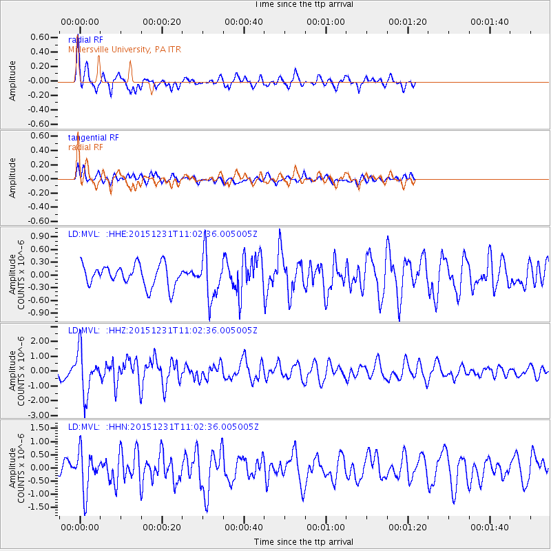
MVL Millersville University, PA - Earthquake Result Viewer
*The percent match for this event was below the threshold and hence no stack was calculated.
| Earthquake location: |
Near Coast Of Nicaragua |
| Earthquake latitude/longitude: |
11.2/-86.6 |
| Earthquake time(UTC): |
2015/12/31 (365) 10:57:00 GMT |
| Earthquake Depth: |
36 km |
| Earthquake Magnitude: |
5.7 MB |
| Earthquake Catalog/Contributor: |
NEIC PDE/NEIC COMCAT |
|
| Network: |
LD Lamont-Doherty Cooperative Seismographic Network |
| Station: |
MVL Millersville University, PA |
| Lat/Lon: |
40.00 N/76.35 W |
| Elevation: |
91 m |
|
| Distance: |
30.1 deg |
| Az: |
15.863 deg |
| Baz: |
200.436 deg |
| Ray Param: |
$rayparam |
*The percent match for this event was below the threshold and hence was not used in the summary stack. |
|
| Radial Match: |
70.80072 % |
| Radial Bump: |
316 |
| Transverse Match: |
55.676964 % |
| Transverse Bump: |
372 |
| SOD ConfigId: |
7422571 |
| Insert Time: |
2019-04-21 16:14:48.818 +0000 |
| GWidth: |
2.5 |
| Max Bumps: |
400 |
| Tol: |
0.001 |
|
Signal To Noise
| Channel | StoN | STA | LTA |
| LD:MVL: :HHZ:20151231T11:02:36.005005Z | 3.802374 | 1.4830853E-6 | 3.9004192E-7 |
| LD:MVL: :HHN:20151231T11:02:36.005005Z | 2.7025173 | 7.6831185E-7 | 2.842949E-7 |
| LD:MVL: :HHE:20151231T11:02:36.005005Z | 2.2773602 | 5.5965717E-7 | 2.457482E-7 |
| Arrivals |
| Ps | |
| PpPs | |
| PsPs/PpSs | |


