You are here: Home > Network List > IC - New China Digital Seismograph Network Stations List
> Station LSA Tibet, China > Earthquake Result Viewer
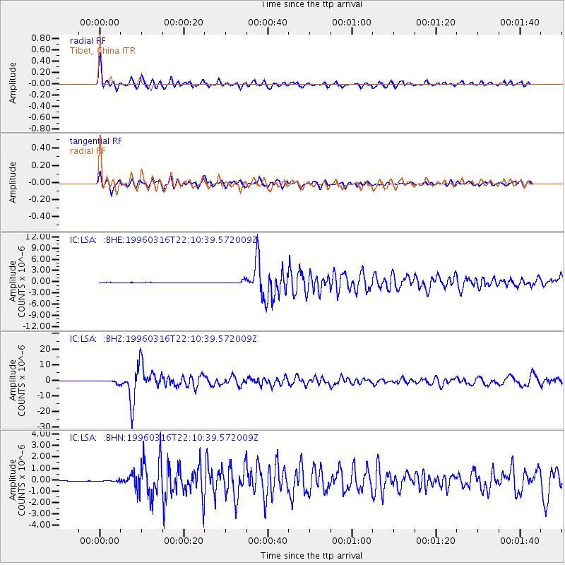
LSA Tibet, China - Earthquake Result Viewer
*The percent match for this event was below the threshold and hence no stack was calculated.
| Earthquake location: |
Bonin Islands, Japan Region |
| Earthquake latitude/longitude: |
29.0/138.9 |
| Earthquake time(UTC): |
1996/03/16 (076) 22:04:06 GMT |
| Earthquake Depth: |
477 km |
| Earthquake Magnitude: |
5.9 MB, 6.6 UNKNOWN, 6.1 MB |
| Earthquake Catalog/Contributor: |
WHDF/NEIC |
|
| Network: |
IC New China Digital Seismograph Network |
| Station: |
LSA Tibet, China |
| Lat/Lon: |
29.70 N/91.15 E |
| Elevation: |
3789 m |
|
| Distance: |
41.4 deg |
| Az: |
283.113 deg |
| Baz: |
78.734 deg |
| Ray Param: |
$rayparam |
*The percent match for this event was below the threshold and hence was not used in the summary stack. |
|
| Radial Match: |
73.98231 % |
| Radial Bump: |
400 |
| Transverse Match: |
77.04323 % |
| Transverse Bump: |
400 |
| SOD ConfigId: |
4480 |
| Insert Time: |
2010-03-04 22:59:00.693 +0000 |
| GWidth: |
2.5 |
| Max Bumps: |
400 |
| Tol: |
0.001 |
|
Signal To Noise
| Channel | StoN | STA | LTA |
| IC:LSA: :BHZ:19960316T22:10:39.572009Z | 9.486552 | 9.782482E-7 | 1.0311946E-7 |
| IC:LSA: :BHN:19960316T22:10:39.572009Z | 1.9143901 | 4.2096957E-8 | 2.198975E-8 |
| IC:LSA: :BHE:19960316T22:10:39.572009Z | 9.788742 | 3.9717128E-7 | 4.0574292E-8 |
| Arrivals |
| Ps | |
| PpPs | |
| PsPs/PpSs | |


