You are here: Home > Network List > US - United States National Seismic Network Stations List
> Station DGMT Dagmar, Montana, USA > Earthquake Result Viewer
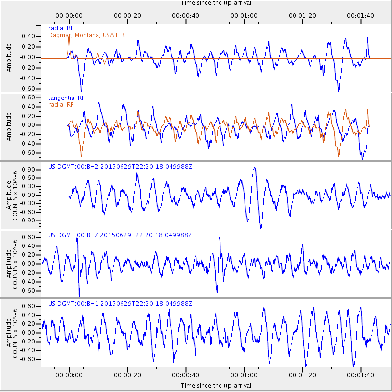
DGMT Dagmar, Montana, USA - Earthquake Result Viewer
*The percent match for this event was below the threshold and hence no stack was calculated.
| Earthquake location: |
Afghanistan-Tajikistan Bord Reg. |
| Earthquake latitude/longitude: |
36.7/71.3 |
| Earthquake time(UTC): |
2015/06/29 (180) 22:07:48 GMT |
| Earthquake Depth: |
190 km |
| Earthquake Magnitude: |
5.5 MB |
| Earthquake Catalog/Contributor: |
NEIC PDE/NEIC ALERT |
|
| Network: |
US United States National Seismic Network |
| Station: |
DGMT Dagmar, Montana, USA |
| Lat/Lon: |
48.47 N/104.20 W |
| Elevation: |
0.0 m |
|
| Distance: |
95.1 deg |
| Az: |
356.981 deg |
| Baz: |
3.647 deg |
| Ray Param: |
$rayparam |
*The percent match for this event was below the threshold and hence was not used in the summary stack. |
|
| Radial Match: |
55.16133 % |
| Radial Bump: |
400 |
| Transverse Match: |
52.380043 % |
| Transverse Bump: |
400 |
| SOD ConfigId: |
976571 |
| Insert Time: |
2015-07-13 22:26:28.930 +0000 |
| GWidth: |
2.5 |
| Max Bumps: |
400 |
| Tol: |
0.001 |
|
Signal To Noise
| Channel | StoN | STA | LTA |
| US:DGMT:00:BHZ:20150629T22:20:18.049988Z | 1.9672749 | 2.788753E-7 | 1.4175716E-7 |
| US:DGMT:00:BH1:20150629T22:20:18.049988Z | 0.58939344 | 1.6906246E-7 | 2.868414E-7 |
| US:DGMT:00:BH2:20150629T22:20:18.049988Z | 1.0978535 | 3.496896E-7 | 3.1852116E-7 |
| Arrivals |
| Ps | |
| PpPs | |
| PsPs/PpSs | |


