You are here: Home > Network List > TA - USArray Transportable Network (new EarthScope stations) Stations List
> Station G05D Wamic, OR, USA > Earthquake Result Viewer
G05D Wamic, OR, USA - Earthquake Result Viewer
*The percent match for this event was below the threshold and hence no stack was calculated.
| Earthquake location: |
Near Coast Of Nicaragua |
| Earthquake latitude/longitude: |
11.2/-86.6 |
| Earthquake time(UTC): |
2015/12/31 (365) 10:57:00 GMT |
| Earthquake Depth: |
36 km |
| Earthquake Magnitude: |
5.7 MB |
| Earthquake Catalog/Contributor: |
NEIC PDE/NEIC COMCAT |
|
| Network: |
TA USArray Transportable Network (new EarthScope stations) |
| Station: |
G05D Wamic, OR, USA |
| Lat/Lon: |
45.24 N/121.32 W |
| Elevation: |
592 m |
|
| Distance: |
45.1 deg |
| Az: |
325.395 deg |
| Baz: |
127.925 deg |
| Ray Param: |
$rayparam |
*The percent match for this event was below the threshold and hence was not used in the summary stack. |
|
| Radial Match: |
38.7214 % |
| Radial Bump: |
294 |
| Transverse Match: |
61.73999 % |
| Transverse Bump: |
400 |
| SOD ConfigId: |
7422571 |
| Insert Time: |
2019-04-21 16:17:28.527 +0000 |
| GWidth: |
2.5 |
| Max Bumps: |
400 |
| Tol: |
0.001 |
|
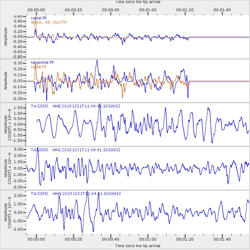
Signal To Noise
| Channel | StoN | STA | LTA |
| TA:G05D: :HHZ:20151231T11:04:41.929993Z | 3.9860442 | 1.6879815E-6 | 4.2347284E-7 |
| TA:G05D: :HHN:20151231T11:04:41.929993Z | 0.9419952 | 5.003383E-7 | 5.3114735E-7 |
| TA:G05D: :HHE:20151231T11:04:41.929993Z | 1.4449909 | 9.4761526E-7 | 6.5579326E-7 |
| Arrivals |
| Ps | |
| PpPs | |
| PsPs/PpSs | |


