You are here: Home > Network List > TA - USArray Transportable Network (new EarthScope stations) Stations List
> Station J05D Fort Rock, OR, USA > Earthquake Result Viewer
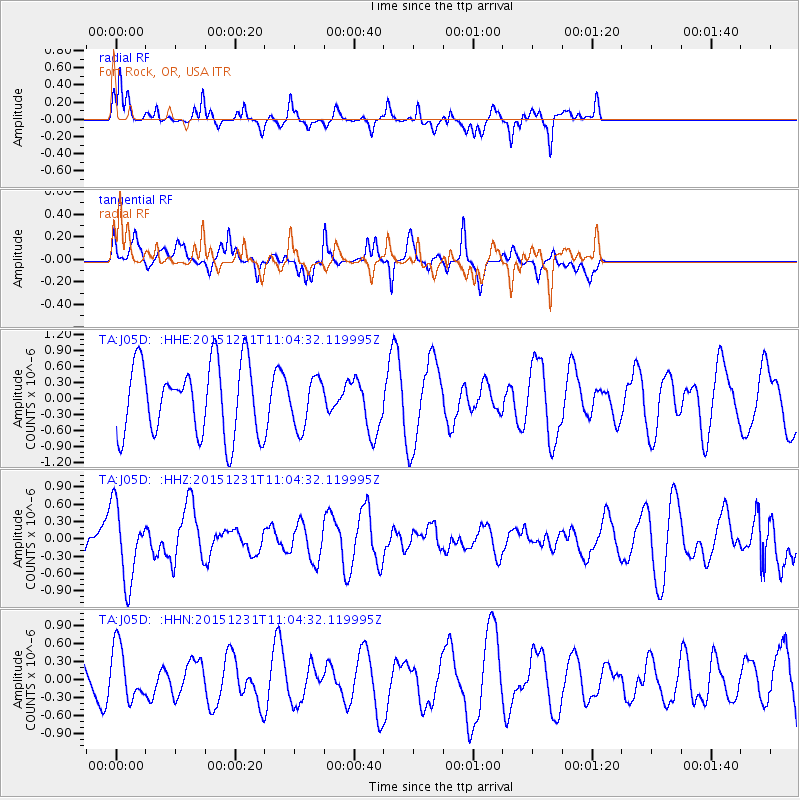
J05D Fort Rock, OR, USA - Earthquake Result Viewer
*The percent match for this event was below the threshold and hence no stack was calculated.
| Earthquake location: |
Near Coast Of Nicaragua |
| Earthquake latitude/longitude: |
11.2/-86.6 |
| Earthquake time(UTC): |
2015/12/31 (365) 10:57:00 GMT |
| Earthquake Depth: |
36 km |
| Earthquake Magnitude: |
5.7 MB |
| Earthquake Catalog/Contributor: |
NEIC PDE/NEIC COMCAT |
|
| Network: |
TA USArray Transportable Network (new EarthScope stations) |
| Station: |
J05D Fort Rock, OR, USA |
| Lat/Lon: |
43.28 N/121.23 W |
| Elevation: |
1541 m |
|
| Distance: |
43.8 deg |
| Az: |
323.219 deg |
| Baz: |
126.429 deg |
| Ray Param: |
$rayparam |
*The percent match for this event was below the threshold and hence was not used in the summary stack. |
|
| Radial Match: |
70.94114 % |
| Radial Bump: |
349 |
| Transverse Match: |
48.744144 % |
| Transverse Bump: |
306 |
| SOD ConfigId: |
7422571 |
| Insert Time: |
2019-04-21 16:17:33.283 +0000 |
| GWidth: |
2.5 |
| Max Bumps: |
400 |
| Tol: |
0.001 |
|
Signal To Noise
| Channel | StoN | STA | LTA |
| TA:J05D: :HHZ:20151231T11:04:32.119995Z | 1.7989831 | 6.4495663E-7 | 3.585118E-7 |
| TA:J05D: :HHN:20151231T11:04:32.119995Z | 1.0989081 | 4.4485435E-7 | 4.048149E-7 |
| TA:J05D: :HHE:20151231T11:04:32.119995Z | 0.6729924 | 4.4977955E-7 | 6.6832786E-7 |
| Arrivals |
| Ps | |
| PpPs | |
| PsPs/PpSs | |


