You are here: Home > Network List > TA - USArray Transportable Network (new EarthScope stations) Stations List
> Station N59A State Game Land 141, Hazleton, PA, USA > Earthquake Result Viewer
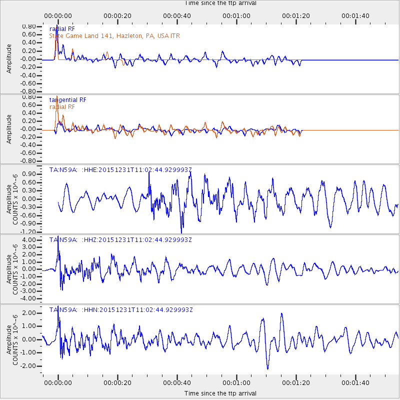
N59A State Game Land 141, Hazleton, PA, USA - Earthquake Result Viewer
*The percent match for this event was below the threshold and hence no stack was calculated.
| Earthquake location: |
Near Coast Of Nicaragua |
| Earthquake latitude/longitude: |
11.2/-86.6 |
| Earthquake time(UTC): |
2015/12/31 (365) 10:57:00 GMT |
| Earthquake Depth: |
36 km |
| Earthquake Magnitude: |
5.7 MB |
| Earthquake Catalog/Contributor: |
NEIC PDE/NEIC COMCAT |
|
| Network: |
TA USArray Transportable Network (new EarthScope stations) |
| Station: |
N59A State Game Land 141, Hazleton, PA, USA |
| Lat/Lon: |
40.92 N/75.77 W |
| Elevation: |
508 m |
|
| Distance: |
31.1 deg |
| Az: |
16.04 deg |
| Baz: |
200.964 deg |
| Ray Param: |
$rayparam |
*The percent match for this event was below the threshold and hence was not used in the summary stack. |
|
| Radial Match: |
71.56908 % |
| Radial Bump: |
361 |
| Transverse Match: |
64.35949 % |
| Transverse Bump: |
389 |
| SOD ConfigId: |
7422571 |
| Insert Time: |
2019-04-21 16:17:44.349 +0000 |
| GWidth: |
2.5 |
| Max Bumps: |
400 |
| Tol: |
0.001 |
|
Signal To Noise
| Channel | StoN | STA | LTA |
| TA:N59A: :HHZ:20151231T11:02:44.929993Z | 4.350367 | 1.4531875E-6 | 3.340379E-7 |
| TA:N59A: :HHN:20151231T11:02:44.929993Z | 5.7686944 | 8.6248843E-7 | 1.4951189E-7 |
| TA:N59A: :HHE:20151231T11:02:44.929993Z | 1.2985604 | 3.133388E-7 | 2.4129704E-7 |
| Arrivals |
| Ps | |
| PpPs | |
| PsPs/PpSs | |


