You are here: Home > Network List > TA - USArray Transportable Network (new EarthScope stations) Stations List
> Station O03E Paynes Creek, CA, USA > Earthquake Result Viewer
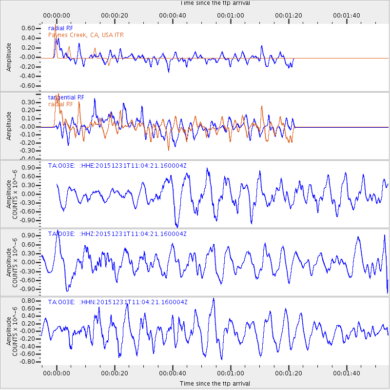
O03E Paynes Creek, CA, USA - Earthquake Result Viewer
*The percent match for this event was below the threshold and hence no stack was calculated.
| Earthquake location: |
Near Coast Of Nicaragua |
| Earthquake latitude/longitude: |
11.2/-86.6 |
| Earthquake time(UTC): |
2015/12/31 (365) 10:57:00 GMT |
| Earthquake Depth: |
36 km |
| Earthquake Magnitude: |
5.7 MB |
| Earthquake Catalog/Contributor: |
NEIC PDE/NEIC COMCAT |
|
| Network: |
TA USArray Transportable Network (new EarthScope stations) |
| Station: |
O03E Paynes Creek, CA, USA |
| Lat/Lon: |
40.29 N/121.80 W |
| Elevation: |
967 m |
|
| Distance: |
42.5 deg |
| Az: |
319.277 deg |
| Baz: |
123.175 deg |
| Ray Param: |
$rayparam |
*The percent match for this event was below the threshold and hence was not used in the summary stack. |
|
| Radial Match: |
62.27231 % |
| Radial Bump: |
400 |
| Transverse Match: |
53.81801 % |
| Transverse Bump: |
400 |
| SOD ConfigId: |
7422571 |
| Insert Time: |
2019-04-21 16:17:45.593 +0000 |
| GWidth: |
2.5 |
| Max Bumps: |
400 |
| Tol: |
0.001 |
|
Signal To Noise
| Channel | StoN | STA | LTA |
| TA:O03E: :HHZ:20151231T11:04:21.160004Z | 5.3013763 | 6.7265626E-7 | 1.2688334E-7 |
| TA:O03E: :HHN:20151231T11:04:21.160004Z | 1.0235108 | 1.7516918E-7 | 1.7114542E-7 |
| TA:O03E: :HHE:20151231T11:04:21.160004Z | 1.2475276 | 2.269226E-7 | 1.8189785E-7 |
| Arrivals |
| Ps | |
| PpPs | |
| PsPs/PpSs | |


