You are here: Home > Network List > TA - USArray Transportable Network (new EarthScope stations) Stations List
> Station R11A Troy Canyon, Currant, NV, USA > Earthquake Result Viewer
R11A Troy Canyon, Currant, NV, USA - Earthquake Result Viewer
*The percent match for this event was below the threshold and hence no stack was calculated.
| Earthquake location: |
Near Coast Of Nicaragua |
| Earthquake latitude/longitude: |
11.2/-86.6 |
| Earthquake time(UTC): |
2015/12/31 (365) 10:57:00 GMT |
| Earthquake Depth: |
36 km |
| Earthquake Magnitude: |
5.7 MB |
| Earthquake Catalog/Contributor: |
NEIC PDE/NEIC COMCAT |
|
| Network: |
TA USArray Transportable Network (new EarthScope stations) |
| Station: |
R11A Troy Canyon, Currant, NV, USA |
| Lat/Lon: |
38.35 N/115.59 W |
| Elevation: |
1756 m |
|
| Distance: |
37.4 deg |
| Az: |
321.229 deg |
| Baz: |
128.6 deg |
| Ray Param: |
$rayparam |
*The percent match for this event was below the threshold and hence was not used in the summary stack. |
|
| Radial Match: |
48.77829 % |
| Radial Bump: |
400 |
| Transverse Match: |
41.437695 % |
| Transverse Bump: |
299 |
| SOD ConfigId: |
7422571 |
| Insert Time: |
2019-04-21 16:17:49.834 +0000 |
| GWidth: |
2.5 |
| Max Bumps: |
400 |
| Tol: |
0.001 |
|
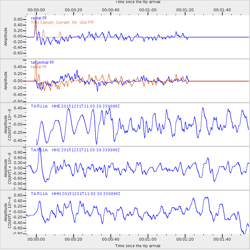
Signal To Noise
| Channel | StoN | STA | LTA |
| TA:R11A: :HHZ:20151231T11:03:39.339996Z | 3.8464074 | 6.007579E-7 | 1.5618676E-7 |
| TA:R11A: :HHN:20151231T11:03:39.339996Z | 2.2904248 | 2.645358E-7 | 1.154964E-7 |
| TA:R11A: :HHE:20151231T11:03:39.339996Z | 1.3164259 | 2.9786526E-7 | 2.2626813E-7 |
| Arrivals |
| Ps | |
| PpPs | |
| PsPs/PpSs | |


