You are here: Home > Network List > US - United States National Seismic Network Stations List
> Station ERPA Erie, Pennsylvania, USA > Earthquake Result Viewer
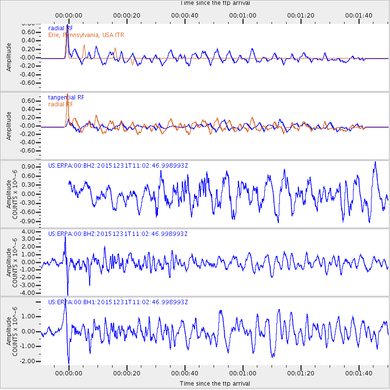
ERPA Erie, Pennsylvania, USA - Earthquake Result Viewer
*The percent match for this event was below the threshold and hence no stack was calculated.
| Earthquake location: |
Near Coast Of Nicaragua |
| Earthquake latitude/longitude: |
11.2/-86.6 |
| Earthquake time(UTC): |
2015/12/31 (365) 10:57:00 GMT |
| Earthquake Depth: |
36 km |
| Earthquake Magnitude: |
5.7 MB |
| Earthquake Catalog/Contributor: |
NEIC PDE/NEIC COMCAT |
|
| Network: |
US United States National Seismic Network |
| Station: |
ERPA Erie, Pennsylvania, USA |
| Lat/Lon: |
42.12 N/79.99 W |
| Elevation: |
306 m |
|
| Distance: |
31.4 deg |
| Az: |
9.524 deg |
| Baz: |
192.605 deg |
| Ray Param: |
$rayparam |
*The percent match for this event was below the threshold and hence was not used in the summary stack. |
|
| Radial Match: |
68.41891 % |
| Radial Bump: |
400 |
| Transverse Match: |
51.79596 % |
| Transverse Bump: |
400 |
| SOD ConfigId: |
7422571 |
| Insert Time: |
2019-04-21 16:18:06.257 +0000 |
| GWidth: |
2.5 |
| Max Bumps: |
400 |
| Tol: |
0.001 |
|
Signal To Noise
| Channel | StoN | STA | LTA |
| US:ERPA:00:BHZ:20151231T11:02:46.998993Z | 3.0450404 | 1.0465783E-6 | 3.4369933E-7 |
| US:ERPA:00:BH1:20151231T11:02:46.998993Z | 2.465396 | 7.779794E-7 | 3.1555962E-7 |
| US:ERPA:00:BH2:20151231T11:02:46.998993Z | 1.5447861 | 3.8295173E-7 | 2.4789952E-7 |
| Arrivals |
| Ps | |
| PpPs | |
| PsPs/PpSs | |


