You are here: Home > Network List > IC - New China Digital Seismograph Network Stations List
> Station LSA Tibet, China > Earthquake Result Viewer
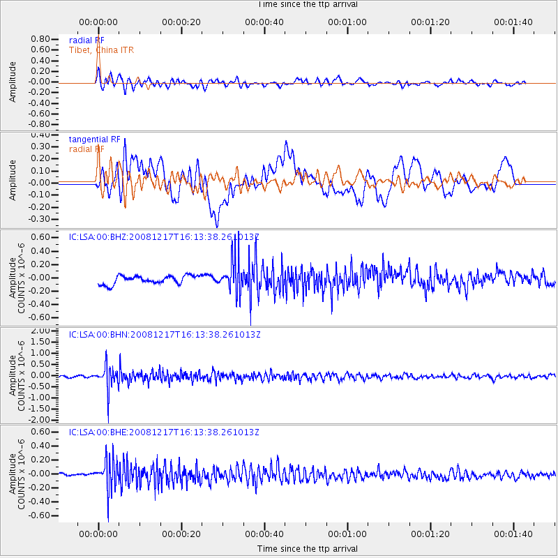
LSA Tibet, China - Earthquake Result Viewer
*The percent match for this event was below the threshold and hence no stack was calculated.
| Earthquake location: |
Southwest Of Sumatra, Indonesia |
| Earthquake latitude/longitude: |
-6.1/103.5 |
| Earthquake time(UTC): |
2008/12/17 (352) 16:06:58 GMT |
| Earthquake Depth: |
35 km |
| Earthquake Magnitude: |
5.7 MB, 4.6 MS, 5.2 MW, 5.2 MW |
| Earthquake Catalog/Contributor: |
WHDF/NEIC |
|
| Network: |
IC New China Digital Seismograph Network |
| Station: |
LSA Tibet, China |
| Lat/Lon: |
29.70 N/91.15 E |
| Elevation: |
3789 m |
|
| Distance: |
37.5 deg |
| Az: |
342.179 deg |
| Baz: |
159.525 deg |
| Ray Param: |
$rayparam |
*The percent match for this event was below the threshold and hence was not used in the summary stack. |
|
| Radial Match: |
79.76689 % |
| Radial Bump: |
400 |
| Transverse Match: |
66.6747 % |
| Transverse Bump: |
400 |
| SOD ConfigId: |
2658 |
| Insert Time: |
2010-03-04 22:59:14.448 +0000 |
| GWidth: |
2.5 |
| Max Bumps: |
400 |
| Tol: |
0.001 |
|
Signal To Noise
| Channel | StoN | STA | LTA |
| IC:LSA:00:BHN:20081217T16:13:38.261013Z | 11.100797 | 5.204032E-7 | 4.6879805E-8 |
| IC:LSA:00:BHE:20081217T16:13:38.261013Z | 9.593548 | 2.1417368E-7 | 2.2324764E-8 |
| IC:LSA:00:BHZ:20081217T16:13:38.261013Z | 3.9976714 | 2.4756156E-7 | 6.192644E-8 |
| Arrivals |
| Ps | |
| PpPs | |
| PsPs/PpSs | |


