You are here: Home > Network List > US - United States National Seismic Network Stations List
> Station MSO Missoula, Montana, USA > Earthquake Result Viewer
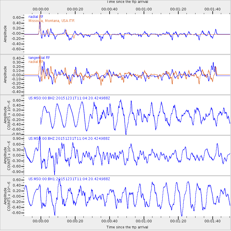
MSO Missoula, Montana, USA - Earthquake Result Viewer
*The percent match for this event was below the threshold and hence no stack was calculated.
| Earthquake location: |
Near Coast Of Nicaragua |
| Earthquake latitude/longitude: |
11.2/-86.6 |
| Earthquake time(UTC): |
2015/12/31 (365) 10:57:00 GMT |
| Earthquake Depth: |
36 km |
| Earthquake Magnitude: |
5.7 MB |
| Earthquake Catalog/Contributor: |
NEIC PDE/NEIC COMCAT |
|
| Network: |
US United States National Seismic Network |
| Station: |
MSO Missoula, Montana, USA |
| Lat/Lon: |
46.83 N/113.94 W |
| Elevation: |
1264 m |
|
| Distance: |
42.4 deg |
| Az: |
332.143 deg |
| Baz: |
138.102 deg |
| Ray Param: |
$rayparam |
*The percent match for this event was below the threshold and hence was not used in the summary stack. |
|
| Radial Match: |
68.59158 % |
| Radial Bump: |
295 |
| Transverse Match: |
51.495846 % |
| Transverse Bump: |
372 |
| SOD ConfigId: |
7422571 |
| Insert Time: |
2019-04-21 16:18:13.845 +0000 |
| GWidth: |
2.5 |
| Max Bumps: |
400 |
| Tol: |
0.001 |
|
Signal To Noise
| Channel | StoN | STA | LTA |
| US:MSO:00:BHZ:20151231T11:04:20.424988Z | 2.2536592 | 5.224265E-7 | 2.3181255E-7 |
| US:MSO:00:BH1:20151231T11:04:20.424988Z | 1.8554945 | 2.9265033E-7 | 1.5772095E-7 |
| US:MSO:00:BH2:20151231T11:04:20.424988Z | 0.8460033 | 2.7432947E-7 | 3.2426524E-7 |
| Arrivals |
| Ps | |
| PpPs | |
| PsPs/PpSs | |


